Glacier Flow Dynamics of the Severnaya Zemlya Archipelago in Russian High Arctic Using the Differential SAR Interferometry (DInSAR) Technique

 , , ,
, , ,
Abstract
:1. Introduction
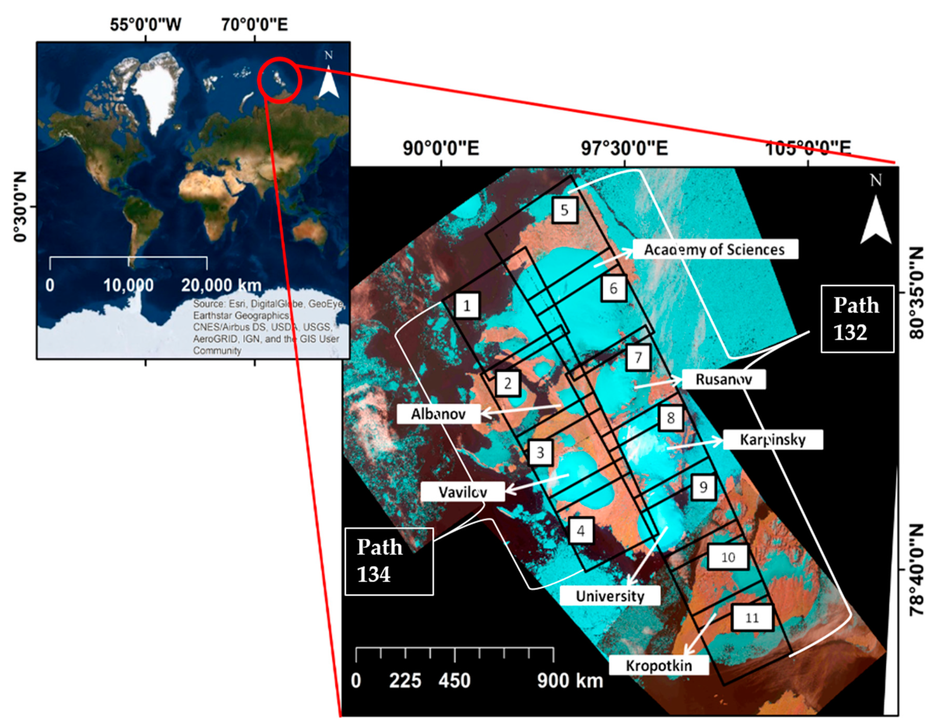
2. Datasets and Study Area
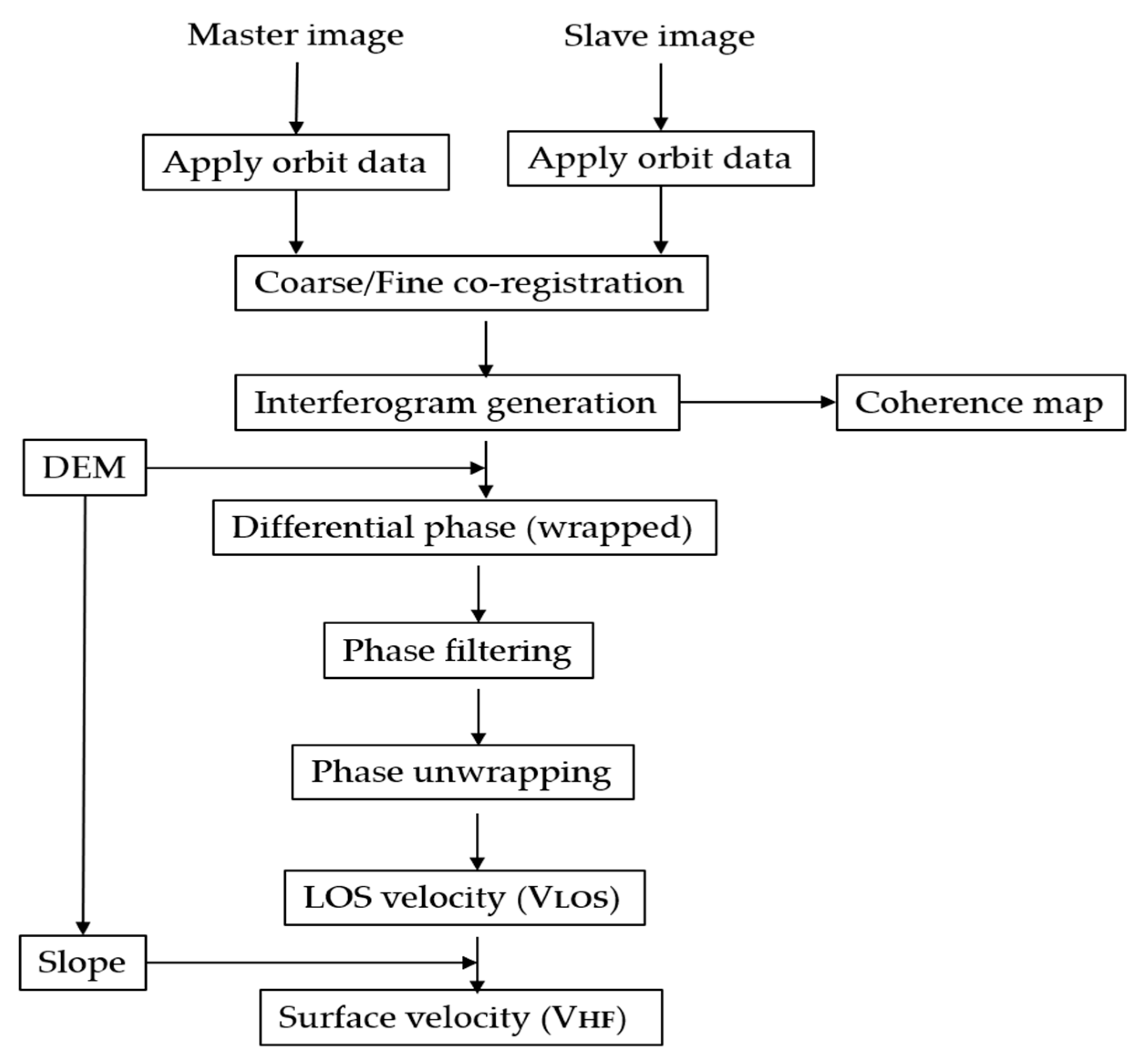
3. Methodology
3.1. Glacier Movement Using DInSAR
3.2. Error Analysis
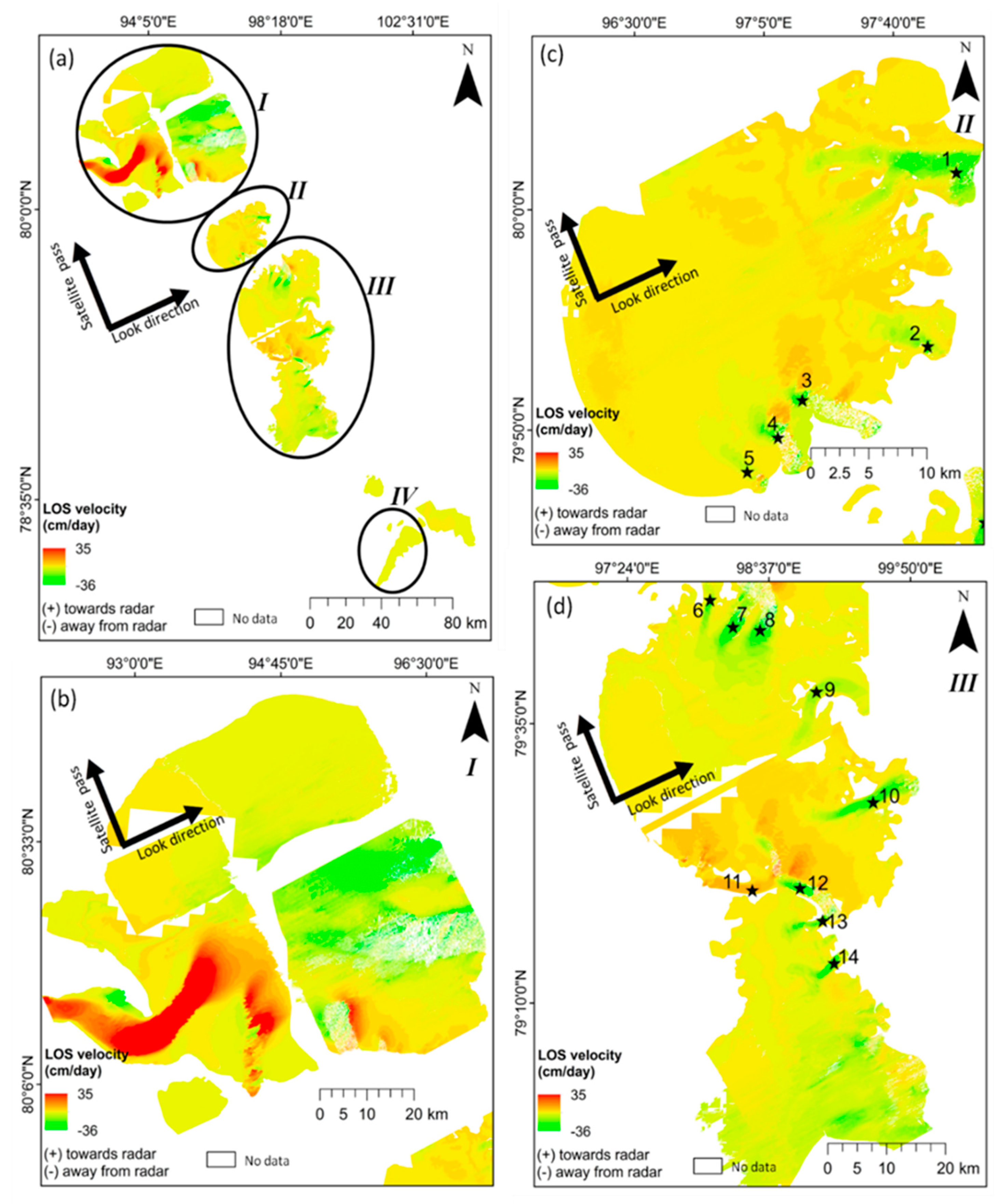
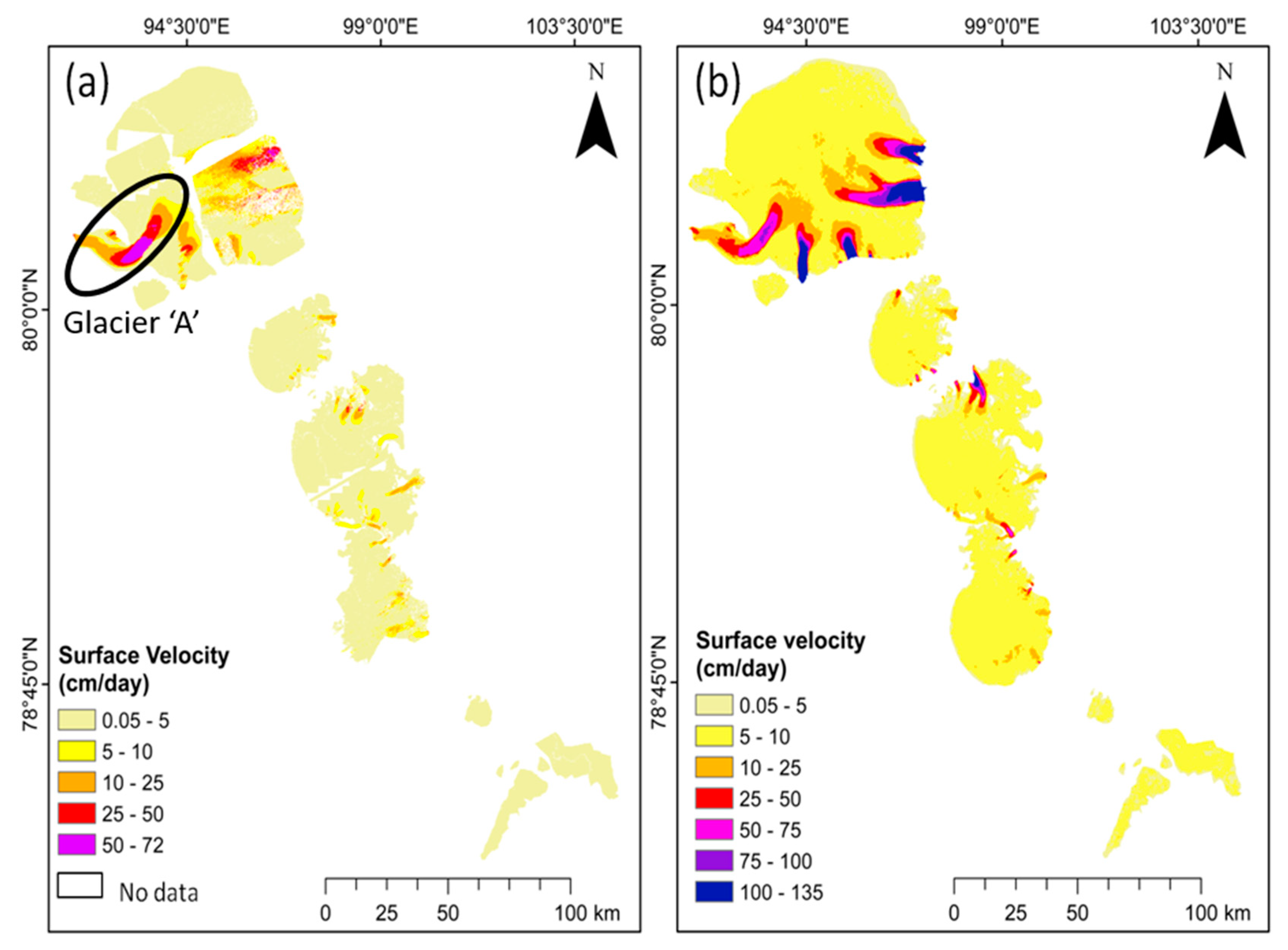
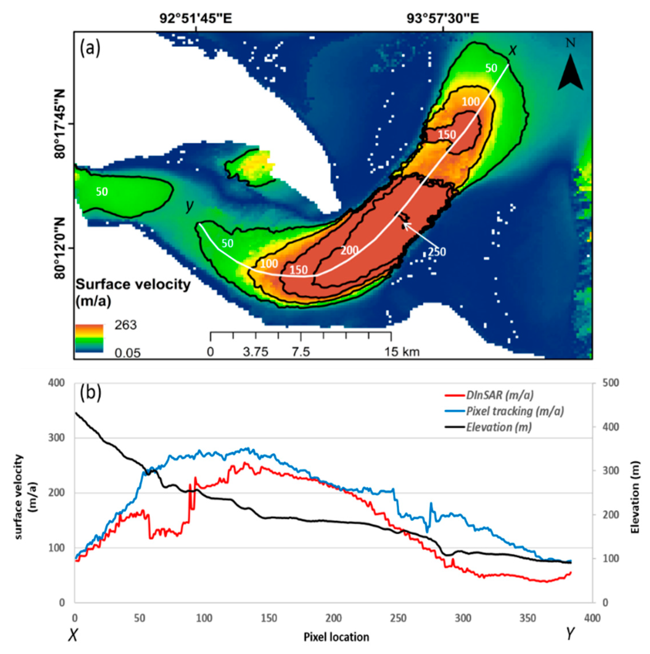
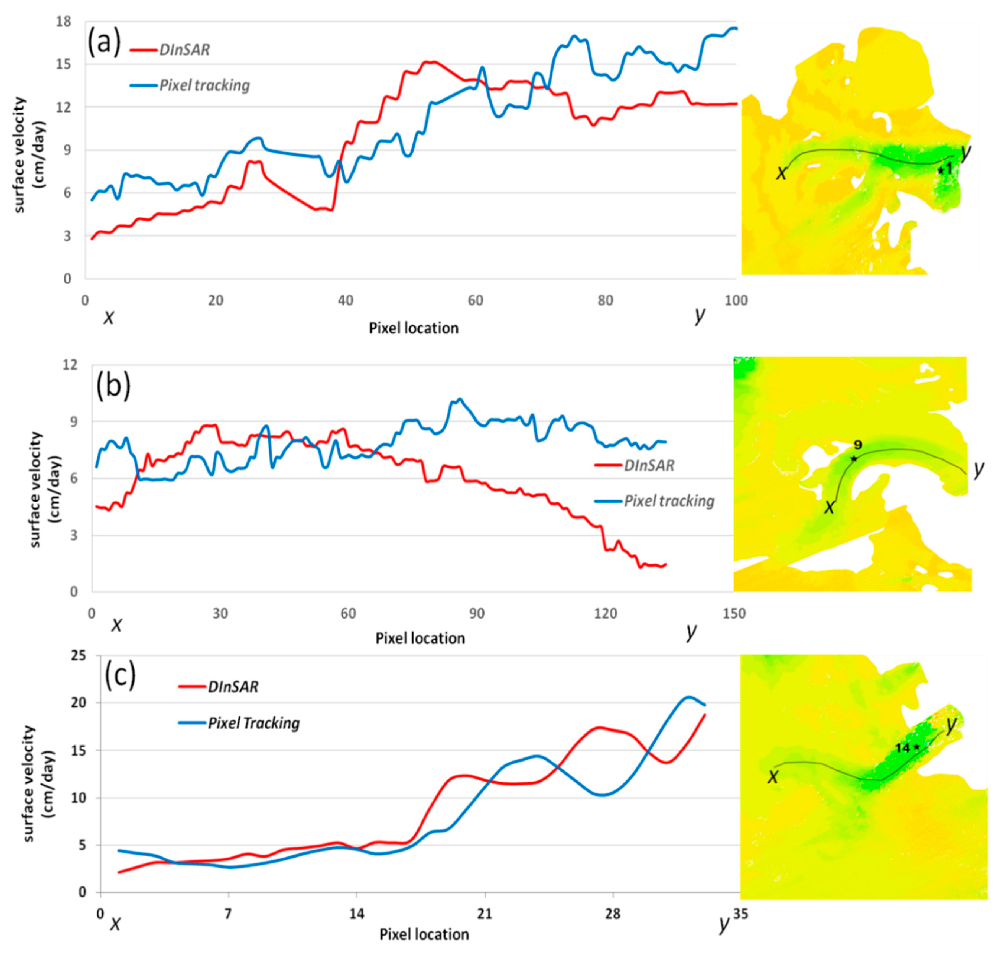
4. Results
5. Discussion
6. Conclusions
Author Contributions
Funding
Acknowledgments
Conflicts of Interest
References
- IPCC. Climate Change: The physical Science Basis. Contribution of Working Group I to the Fourth Assessment Report of the Intergovernmental Panel on Climate Change; Cambridge University Press: Cambridge, UK; New York, NY, USA, 2007.
- Scherler, D.; Bookhagen, B.; Strecker, M.R. Spatially variable response of Himalayan glaciers to climate change affected by debris cover. Nat. Geosci. 2011, 4, 156–159. [Google Scholar] [CrossRef]
- Kumar, P.; Shukla, A.; Kamal, R.; Singh, A. Assessing the status of glaciers in part of the Chandra basin, Himachal Himalaya: A multiparametric approach. Geomorphology 2017, 284, 99–114. [Google Scholar]
- Space Applications centre. Monitoring Snow and Glaciers of the Himalayas; Space Applications centre: Ahmedabad, India, 2016. [Google Scholar]
- Bhutiyani, M.R.; Kale, V.S.; Pawar, N.J. Climate change and the precipitation variations in the northwestern Himalaya: 1866–2006. Int. J. Climatol. 2010, 30, 535–548. [Google Scholar] [CrossRef]
- Burgess, E.W.; Forster, R.R.; Larsen, C.F. Flow velocities of Alaskan glaciers. Nat. Commun. 2013, 4, 1–8. [Google Scholar] [CrossRef]
- Liu, L.; Jing, Z.; Zhang, X. The application of GPS in glacier flow velocity: A case study of Qiyi Glacier. Appl. Mech. Mater. 2012, 130, 1794–1798. [Google Scholar] [CrossRef]
- Strozzi, T.; Luckman, A.; Murray, T.; Wegmüller, U.; Werner, C.L. Glacier Motion Estimation Using SAR Offset-Tracking Procedures. IEEE Trans. Geosci. Remote Sens. 2002, 40, 2384–2391. [Google Scholar] [CrossRef]
- Satyabala, S.P. Spatiotemporal variations in surface velocity of the Gangotri glacier, Garhwal Himalaya, India: Study using synthetic aperture radar data. Remote Sens. Environ. 2016, 181, 151–161. [Google Scholar] [CrossRef]
- Goldstein, R.M.; Engelhardt, H.; Kamb, B.; Frolich, R.M. Satellite radar interferometry for monitoring ice sheet motion: Application to an Antarctic ice stream. Science 1993, 262, 1525–1530. [Google Scholar] [CrossRef]
- Joughin, I.R.; Winebrenner, D.P. Observations of ice-sheet motion in Greenland using satellite. Geophys. Res. Lett. 1995, 22, 571–574. [Google Scholar] [CrossRef]
- Cheng, X.; Li, X.W.; Shao, Y.; Li, Z. DInAR measurement of glacier motion in Antarctic Grove Mountain. Chin. Sci. Bull. 2007, 52, 358–366. [Google Scholar] [CrossRef]
- Moll, A.; Braun, M.; Lluberas, A. Determination of Glacier Velocities on King George Island (Antarctica) by DInSAR; IGARSS: Denver, CO, USA, 2006; pp. 1236–1239. [Google Scholar]
- Wangensteen, B.; Weydahl, D.A.N.J.; Hagen, J.O.N.O.V.E. Mapping glacier velocities on Svalbard using ERS tandem DInSAR data Mapping glacier velocities on Svalbard using ERS tandem DInSAR data. Nor. Geogr. Tidsskr-Nor. J. Geogr. 2005, 59, 276–285. [Google Scholar] [CrossRef]
- Caló, F.; Notti, D.; Galve, J.P.; Abdikan, S.; Görüm, T.; Pepe, A.; Şanli, F.B. DInSAR-based detection of land subsidence and correlation with groundwater depletion in Konya plain, Turkey. Remote Sens. 2017, 9, 83. [Google Scholar] [CrossRef]
- Tomás, R.; Herrera, G.; Delgado, J.; Lopez-Sanchez, J.M.; Mallorquí, J.J.; Mulas, J. A ground subsidence study based on DInSAR data: Calibration of soil parameters and subsidence prediction in Murcia City (Spain). Eng. Geol. 2010, 111, 19–30. [Google Scholar] [CrossRef]
- Fang, J.; Xu, C.; Wen, Y.; Wang, S.; Xu, G.; Zhao, Y.; Yi, L. The 2018 Mw 7.5 Palu earthquake: A supershear rupture event constrained by InSAR and broadband regional seismograms. Remote Sens. 2019, 11, 1330. [Google Scholar] [CrossRef]
- Mora, O.; Ordoqui, P.; Iglesias, R.; Blanco, P. Earthquake Rapid Mapping Using Ascending and Descending Sentinel-1 TOPSAR Interferograms. Procedia Comput. Sci. 2016, 100, 1135–1140. [Google Scholar] [CrossRef]
- Zebker, H.A.; Rosen, P.A.; Goldstein, R.M.; Gabriel, A.; Werner, C.L. On the derivation of coseismic displacement fields using differential radar interferometry: The Landers earthquake. J. Geophys. Res. 1994, 99, 617–634. [Google Scholar] [CrossRef]
- Lu, Z.; Freymueller, J.T. Synthetic aperture radar interferometry coherence analysis over Katmai volcano group, Alaska. J. Geophys. Res. Solid Earth 1998, 103, 29887–29894. [Google Scholar] [CrossRef]
- Chaussard, E.; Amelung, F.; Aoki, Y. Characterization of open and closed volcanic systems in Indonesia and Mexico using InSAR time series. J. Geophys. Res. Solid Earth 2013, 118, 3957–3969. [Google Scholar] [CrossRef]
- Massonnet, D.; Rossi, M.; Carmona, C.; Adragna, F.; Peltzer, G.; Feigl, K.; Rabaute, T. The displacement field of the Landers earthquake mapped By Radar Interferometry. Nature 1993, 364, 138–142. [Google Scholar] [CrossRef]
- Kumar, V.; Venkataraman, G.; Larsen, Y. IGARSS. In Proceedings of the SAR Interferometry and offset tracking approaches for glacier movement estimation in the Himalaya, Vancouver, BC, Canada, 24–29 July 2011; pp. 3175–3178. [Google Scholar]
- Sánchez-gámez, P.; Navarro, F.J. Glacier Surface Velocity Retrieval Using D-InSAR and Offset Tracking Techniques Applied to Ascending and Descending Passes of Sentinel-1 Data for Southern Ellesmere Ice Caps, Canadian Arctic. Remote Sens. 2017, 9, 442. [Google Scholar] [CrossRef]
- Wang, T.; Jónsson, S. Improved SAR amplitude image offset measurements for deriving three-dimensional coseismic displacements. IEEE J. Sel. Top. Appl. Earth Obs. Remote Sens. 2015, 8, 3271–3278. [Google Scholar] [CrossRef]
- Ou, D.; Tan, K.; Du, Q.; Chen, Y.; Ding, J. Decision fusion of D-InSAR and pixel offset tracking for coal mining deformation monitoring. Remote Sens. 2018, 10, 1055. [Google Scholar] [CrossRef]
- Dowdeswell, J.A.; Bassford, R.P.; Gorman, M.R.; Williams, M.; Glazovsky, A.F.; Macheret, Y.Y.; Shepherd, A.P.; Vasilenko, Y.V.; Savatyuguin, L.M.; Hubberten, H.W.; et al. Form and flow of the Academy of Sciences Ice Cap, Severnaya Zemlya, Russian High Arctic. J. Geophys. Res. 2002, 107, EPM-5. [Google Scholar] [CrossRef]
- Sánchez-Gámez, P.; Navarro, F.J.; Glazovsky, A.F.; Bassford, R.P.; Dowdeswell, J.A. Intra- and inter-annual variability in dynamic discharge from the Academy of Sciences Ice Cap, Severnaya Zemlya, Russian Arctic, and its role in modulating mass balance. J. Glaciol. 2019, 65, 780–797. [Google Scholar] [CrossRef]
- Willis, M.J.; Zheng, W.; Durkin, W.J., IV; Pritchard, M.E.; Ramage, J.M.; Dowdeswell, J.A.; Benham, T.J.; Bassford, R.P.; Stearns, L.A.; Glazovsky, A.F.; et al. Massive destabilization of an Arctic ice cap. Earth Planet. Sci. Lett. 2018, 502, 146–155. [Google Scholar] [CrossRef]
- Gardner, A.S.; Fahnestock, M.A.; Scambos, T.A. Sept,2019:ITS_LIVE Regional Glacier and Ice Sheet Surface Velocities; Data archived at National Snow and Ice Data Center: Pasadena, CA, USA, 2019. [Google Scholar]
- Raju, N.B.; Singh, G.; Anil, V.K.; Kapil, M. Optimum Conditions for Differential Sar Interferometry Technique to Estimate Himalayan Glacier Velocity. In Proceedings of the ISPRS Ann. Photogramm. Remote Sens. Spatial Inf. Sci., Dehradun, India, 20–23 November 2018; Volume IV-5, pp. 137–140. [Google Scholar]
- Gardner, A.S.; Moholdt, G.; Scambos, T.; Fahnstock, M.; Ligtenberg, S.; Broeke, M. Van Den Increased West Antarctic and unchanged East Antarctic ice discharge over the last 7 years. Cryosphere 2018, 12, 521–547. [Google Scholar] [CrossRef]
- Strozzi, T.; Paul, F.; Wiesmann, A.; Schellenberger, T.; Kääb, A. Circum-arctic changes in the flow of glaciers and ice caps from satellite SAR data between the 1990s and 2017. Remote Sens. 2017, 9, 947. [Google Scholar] [CrossRef]
- Michael, A.; Robert, C. ASTER Global Digital Elevation Model V003; NASA EOSDIS Land Processes DAAC; NASA/METI/AIST/Japan Spacesystems, and U.S./Japan ASTER Science Team: Pasadena, CA, USA, 2018.
- Tao, Q.; Gao, T.; Liu, G.; Wang, Z. Effect of external digital elevation model on monitoring of mine subsidence by two-pass differential interferometric synthetic aperture radar. J. Appl. Remote Sens. 2017, 11, 026037. [Google Scholar] [CrossRef]
- Doyle, S.H.; Hubbard, B.; Christoffersen, P.; Young, T.J.; Hofstede, C.; Bougamont, M.; Box, J.E.; Hubbard, A. Physical Conditions of Fast Glacier Flow: 1. Measurements From Boreholes Drilled to the Bed of Store Glacier, West Greenland. J. Geophys. Res. Earth Surf. Res. 2018, 123, 324–348. [Google Scholar] [CrossRef]
- Dowdeswell, J.A.; Williams, M. Surge-type glaciers in the Russian High Arctic identified from digital satellite imagery. J. Glaciol. 1997, 43, 489–494. [Google Scholar] [CrossRef] [Green Version]


| Pair No. | Dates | Path Number | Temporal Baseline (days) | Polarization |
|---|---|---|---|---|
| 1 to 4 | 28/03/2014 | 134 | 0 | HH + HV |
| 11/04/2018 | 134 | 14 | HH + HV | |
| 5 to 11 | 01/04/2018 | 132 | 0 | HH + HV |
| 15/04/2018 | 132 | 14 | HH + HV |
| Glacier No | Observed Max Velocity (cm/day) | Ice Cap | Type of Glacier | Description |
|---|---|---|---|---|
| 1 | 21.93 | Rusanov | Marine-terminating | High at the terminus (increasing gradually) |
| 2 | 11.49 | Rusanov | Marine-terminating | High at the terminus (increasing gradually) |
| 3 | 20.48 | Rusanov | Marine-terminating | High velocity in the middle part (frontal area has no data) |
| 4 | 17.71 | Rusanov | Marine-terminating | High velocity in the middle part (frontal area has no data) |
| 5 | 11.76 | Rusanov | Marine-terminating | Near the terminus (velocity is almost uniform) |
| 6 | 19.12 | Karpinsky | Marine-terminating | High velocity in the middle part (low–high–low) |
| 7 | 32.12 | Karpinsky | Marine-terminating | High velocity in the middle part (frontal area has no data) |
| 8 | 26.19 | Karpinsky | Marine-terminating | High velocity in the middle part (frontal area has no data) |
| 9 | 8.89 | Karpinsky | Marine-terminating | High velocity in the middle part (low–high–low) |
| 10 | 17.80 | Karpinsky | Marine-terminating | High velocity in the middle part |
| 11 | 7.43 | Karpinsky | Land-terminating | High velocity in the middle part (low–high–low) |
| 12 | 25.48 | Karpinsky | Marine-terminating | High velocity in the middle part (frontal area has no data) |
| 13 | 17.23 | Karpinsky | Marine-terminating | High velocity at the terminus (increasing gradually) |
| 14 | 27.07 | University | Marine-terminating | High velocity at the terminus (increasing gradually) |
| 15 | 6.62 | Kropotkin Glacier | Land-terminating | Constant flow |
| 16 | 72.24 | Glacier ‘A’ | Marine-terminating | High velocity in the middle part (low–high–low) |
| Scene Pair No. | Perpendicular Baseline (m) | Deformation Error in LOS Direction (cm) |
|---|---|---|
| 1 | 33.2 | 0.12 |
| 2 | 36.5 | 0.13 |
| 3 | 39.6 | 0.14 |
| 4 | 43.3 | 0.15 |
| 5 | 15.1 | 0.05 |
| 6 | 13.6 | 0.05 |
| 7 | 12 | 0.04 |
| 8 | 10.4 | 0.04 |
| 9 | 8.8 | 0.03 |
| 10 | 7.3 | 0.03 |
| 11 | 5.7 | 0.02 |
© 2019 by the authors. Licensee MDPI, Basel, Switzerland. This article is an open access article distributed under the terms and conditions of the Creative Commons Attribution (CC BY) license (http://creativecommons.org/licenses/by/4.0/).
Share and Cite
Nela, B.R.; Bandyopadhyay, D.; Singh, G.; Glazovsky, A.F.; Lavrentiev, I.I.; Kromova, T.E.; Arigony-Neto, J. Glacier Flow Dynamics of the Severnaya Zemlya Archipelago in Russian High Arctic Using the Differential SAR Interferometry (DInSAR) Technique. Water 2019, 11, 2466. https://doi.org/10.3390/w11122466
Nela BR, Bandyopadhyay D, Singh G, Glazovsky AF, Lavrentiev II, Kromova TE, Arigony-Neto J. Glacier Flow Dynamics of the Severnaya Zemlya Archipelago in Russian High Arctic Using the Differential SAR Interferometry (DInSAR) Technique. Water. 2019; 11(12):2466. https://doi.org/10.3390/w11122466
Chicago/Turabian StyleNela, Bala Raju, Debmita Bandyopadhyay, Gulab Singh, Andrey F. Glazovsky, Ivan I. Lavrentiev, Tatiana E. Kromova, and Jorge Arigony-Neto. 2019. "Glacier Flow Dynamics of the Severnaya Zemlya Archipelago in Russian High Arctic Using the Differential SAR Interferometry (DInSAR) Technique" Water 11, no. 12: 2466. https://doi.org/10.3390/w11122466