Hurricane “Grace” to make landfall over Yucatan Peninsula, strong winds and dangerous storm surge expected
Hurricane "Grace" is approaching eastern Yucatan Peninsula, Mexico, and is expected to make landfall during the next 6 hours, move across the Yucatan Peninsula today, and move over the southwest Gulf of Mexico late tonight through Friday, the National Hurricane Center (NHC) forecaster Stewart noted at 09:00 UTC on Thursday, August 19, 2021.1
At the time, the center of Hurricane "Grace" was located 115 km (60 miles) ESE of Tulum, Mexico. It had maximum sustained winds of 130 km/h (80 mph), minimum central pressure of 986 hPa, and was moving W at 30 km/h (18 mph).
A general W to WNW motion is expected through Friday, followed by a general westward to west-southwestward motion.
On the forecast track, Grace is expected to make landfall in the eastern Yucatan Peninsula during the next six hours, move across the Yucatan Peninsula today, and move over the southwest Gulf of Mexico late tonight through Friday, August 20.
Some strengthening is expected before landfall on the Yucatan Peninsula.
Grace is expected to weaken as it crosses Yucatan, but re-intensification is expected when the center reaches the Gulf of Mexico.
Hurricane-force winds extend outward up to 55 km (35 miles) from the center and tropical-storm-force winds extend outward up to 220 km (140 miles).

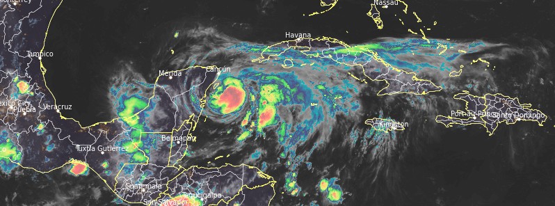
Hurricane "Grace" at 04:50 UTC on August 19, 2021. Credit: GOES-East, RAMMB/CIRA, TW

Hurricane "Grace" at 22:20 UTC on August 18, 2021. Credit: GOES-East, RAMMB/CIRA, TW
A Hurricane Warning is in effect for:
- Yucatan Peninsula of Mexico from Cancun to Punta Herrero, including Cozumel.
A Hurricane Watch is in effect for:
- The coast of mainland Mexico from Puerto Veracruz to Cabo Rojo.
A Tropical Storm Warning is in effect for:
- Yucatan Peninsula of Mexico from north of Cancun to Campeche.
- Yucatan Peninsula of Mexico from south of Punta Herrero to Puerto Costa Maya.
A Tropical Storm Watch is in effect for:
- Southern coast Cuban province of Pinar del Rio, as well as Isla de la Juventud.
- The coast of mainland Mexico north of Cabo Rojo to Puerto de Altamira.
Hurricane conditions and a dangerous storm surge are expected in portions of the Hurricane Warning area in the eastern Yucatan Peninsula of Mexico during the next several hours. Preparations to protect life and property should be rushed to completion, NHC said.
There is an increasing risk of hurricane conditions and dangerous storm surge in portions of eastern mainland Mexico beginning late Friday, and a Hurricane Watch is in effect for part of this area.
Through the weekend, heavy rainfall across central and northern portions of the Yucatan Peninsula and Veracruz State should lead to flash and urban flooding. In addition, the heavy rainfall from Grace will be capable of producing mudslides in Veracruz.

Grace is the 7th named storm and the second hurricane of the 2021 Atlantic hurricane season.
"The long-term (1991 – 2020) average 2nd Atlantic hurricane formation date is August 25," CSU meteorologist Philip Klotzbach said.
"The 2021 Atlantic #hurricane season has already produced 22 named storm days. Only 6 years in the satellite era (>=1966) have produced more Atlantic named storm days by August 18: 1966, 1995, 2005, 2008, 2012 and 2020."2
References:
1 This report is based on Hurricane Grace Intermediate Advisory Number 23A – NWS National Hurricane Center Miami FL – AL072021 100 AM CDT Thu Aug 19 2021
2 Philip Klotzbach – Twitter
Featured image: Hurricane "Grace" at 04:50 UTC on August 19, 2021. Credit: GOES-East, RAMMB/CIRA, TW
Commenting rules and guidelines
We value the thoughts and opinions of our readers and welcome healthy discussions on our website. In order to maintain a respectful and positive community, we ask that all commenters follow these rules.