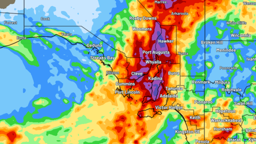
There's no end in sight for South Australia's run of wet weather, with a severe thunderstorm warning and more heavy rain forecast.
It comes after the southern state was hit with "once-in-a-lifetime flooding".
Roads have buckled and parts of the outback have turned into a floodplain after the state was hit with a record-breaking deluge.
The wet weather is being caused by higher-than-normal amounts of tropical moisture and a slow-moving low-pressure trough.
A severe thunderstorm warning is currently in effect for central and northeastern parts of the state and Kangaroo Island.
The Bureau of Meteorology (BoM) warns the storms "are likely to produce heavy rainfall that may lead to flash flooding in the warning area over the next several hours".
Locations which may be affected include Moomba, Innamincka, Arkaroola and the Strzelecki Track south of Moomba.
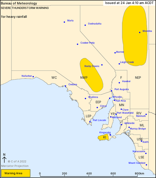
The State Emergency Service (SES) is urging residents in affected areas to avoid driving through floodwaters.
"We've had reports properties are being impacted by floodwater due to vehicles causing waves over sandbags being used to keep the community safe," it said on Twitter.
"Please drive to the conditions. Stay safe by never driving through floodwater."
"We've had reports properties are being impacted by floodwater due to vehicles causing waves over sandbags being used to keep the community safe," it said on Twitter.
"Please drive to the conditions. Stay safe by never driving through floodwater."

Weatherzone predicted there's "a few more days of rain, storms to come".
"A large swathe of South Australia's north and west has been drenched by near-record downpours, amounting to widespread 50-to-150mm, half the annual average in some areas," it wrote.
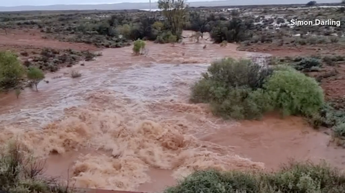
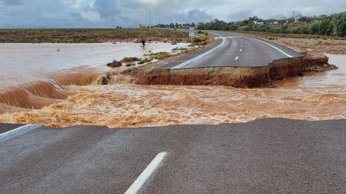
"So far, the state's west and northwest have been dealt the most rain, leading to flooding and swamping some towns. Parched parks and paddocks have turned into lakes deep enough to swim, boat and jet-ski in.
"It's not just the rain getting the locals talking, it's the humidity too. How often can one say SA is more humid than Sydney and Brisbane for a whole week? Maybe once in a lifetime."
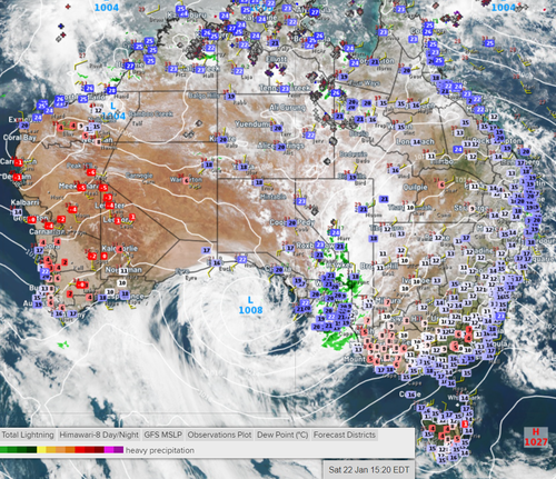
Arcoona Bluff, in the state's north-east, has recorded the heaviest rainfall.
"The highest fall for South Australia in the 24 hours to 9am Sun was 106.8 mm at Arcoona Bluff," the BoM wrote on Twitter.
"Seven annual records were broken over the past few days and so far more than one dozen Jan rainfall records as well."
"Seven annual records were broken over the past few days and so far more than one dozen Jan rainfall records as well."
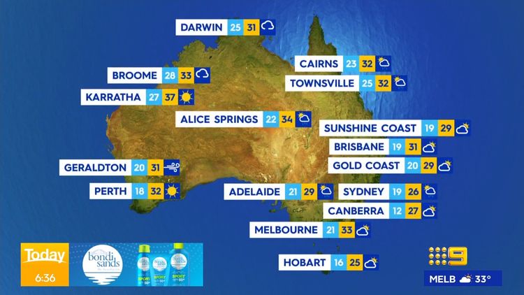
Read on to find out what the weather is doing around the nation's capitals today.
Brisbane
The Sunshine State is in for a cloudy day and is heading for a top of 31C.
Light winds will become easterly 15 to 20 km/h in the late afternoon before becoming light in the evening.
Sydney
Showers are forecast for the Harbour City which is expected to reach a high of 26C.
Rain is most likely in the morning and early afternoon.
06:15 AEST06:20 AEST06:25 AEST06:30 AEST06:35 AEST06:40 AEST06:45 AEST


Canberra
The nation's capital will today reach a maximum temperature of 27C.
It will be a partly cloudy day.
Light winds will become east to northeasterly 15 to 20 km/h in the evening before becoming light in the late evening.
Melbourne
Melbourne has a humid and mostly sunny day ahead.
It will stay in the mid 30s, climbing to a maximum temperature of 33C.
Adelaide
Adelaide is bracing for a humid and wet day.
The BoM has forecast a high chance of showers, which will become less likely in the late morning and early afternoon.
There's also the chance of a thunderstorm.
Winds will tend north to northeasterly 15 to 25 km/h before tending northeast to southeasterly in the evening.
Hobart
Hobart will reach a high of 25C today.
It will be partly cloudy.
Light winds will become southeasterly 25 to 40 km/h in the middle of the day before becoming light in the late evening.
Perth
Perth is in store for a sunny and warm day, with a high of 32C forecast.
Winds will tend southerly 20 to 30 km/h then increase to 35 km/h, before turning southeasterly 20 to 30 km/h in the evening.
Darwin
Darwin will reach a high of 31C with showers and a possible storm on the horizon.
Light winds will becoming northwesterly 15 to 20 km/h in the middle of the day before becoming light in the early afternoon.