New massive eruption at Soufriere St. Vincent, SO2 emissions spreading over two continents
A new high-level, major eruption took place at Soufriere St. Vincent volcano at 10:40 UTC on April 13, 2021. The SO2 emissions produced over the past 2 days are now spreading over two continents — South America and Africa. Extremely heavy ash is covering the island of St. Vincent, leaving the nation without electricity.
The pattern of seismicity changed again, with the end of the episodes of high-amplitude tremor 2 to 8 hours apart, the University of West Indies Seismic Research Center (UWI-SRC) said early April 13, 2021.
Three episodes of tremor have been recorded since 06:00 LT on April 13, 2 of them with lower-amplitude, and the third, at about 17:00 LT, was high-amplitude. The episodes continue to coincide with periods of enhanced venting or explosive activity.
Observations indicate that pyroclastic density currents (PDCs) had descended several valleys on the southern and western flanks of the volcano and had reached the sea at Morne Ronde, Larikai, and Trois Loupes Bay.
Extensive damage to vegetation was noted in an area extending from Larikai Bay to Turner Bay on the west coast. No other areas along the coast had been affected by PDCs but villages located on the eastern flank of the volcano had been affected by heavy ashfall.
Explosions and accompanying ashfall, of similar or larger magnitude, are likely to continue to occur over the next few days with the chance of PDCs occurring, UWI-SRC warned just hours before another massive eruption at 10:40 UTC today:

Image credit: CDEMA. Acquired: April 13, 2021
Video credit: NOAA/GOES-East. Processed by: Antonio Vecoli/TW. Acquired 10:30 to 13:45 UTC on April 13.
Today's eruption came on the volcano's 42nd anniversary of the VEI3 1979 eruption.
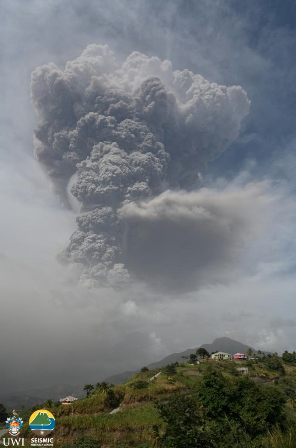
Image credit: UWI-SRC. Acquired April 9, 2021


The images below show the impact of the ongoing eruption in the Red Zone on April 12:

The town of Fitz Hughes (left) and Chateaubelair (right) showing the effects of ash deposits. Photo credit: R. Robertson, UWI-SRC

A pyroclastic density current (PDC) at coastline in Larikai Bay. They often have a fan-like appearance upon stopping. Photo credit: R. Robertson, UWI-SRC

Recon trip with the assistance of the Coast Guard to observe the impact of the ongoing eruption. The village of Owia. Photo credit: R. Robertson, UWI-SRC

Overview of coastline from Baleine/De Volet (left) to Larikai Bay (right). Photo credit: R. Robertson, UWI-SRC

Venting or degassing of a PDC that came down a valley near Larikai. Photo credit: R. Robertson, UWI-SRC.
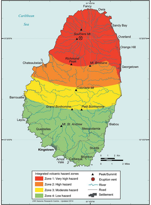
Volcanic Hazard Map – St. Vincent.
The map only shows hazard zone on land. However, lahars and pyroclastic falls, flows and surges will also impact areas offshore to varying degrees, and as such, the hazard zones must be envisaged as extending some distance offshore.
A massive explosion and new pyroclastic flows were produced at 08:15 UTC on April 12, with ash cloud reaching approximately 17 km (55 000 feet) above sea level.
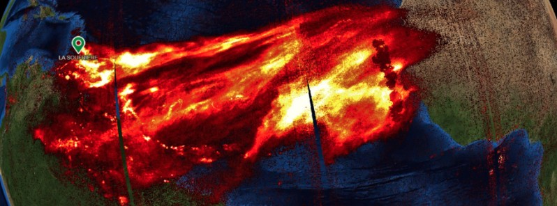
Imagery acquired by Sentinel 5P on April 12 showed SO2 emissions spreading over two continents:

SO2 plume produced by La Soufriere volcano as seen by Sentinel 5P on April 12. Processed by Antonio Vecoli
Extremely heavy ash has covered the island of St. Vincent since the explosive eruptions began on Friday, April 9, leaving the majority of St. Vincent and the Grenadines without power on April 11, 2021.
New observations show changes to the summit crater with a possible smaller vent inside the new crater.
The black/dark areas to the west (left) of the summit are the pyroclastic flow deposits from earlier explosive events.

Image credit: ESA/Sentinel-1, UWI-SRC
Structural changes of the #LaSoufriere volcano summit visible in @CopernicusEU #Sentinel1 images
Images acquired on 5 April (before the eruptions) and on 11 April (today at 9:59 UTC) and processed in @sentinel_hub
cc @CultureVolcan @uwiseismic pic.twitter.com/SivMpquKXB
— Annamaria Luongo (@annamaria_84) April 11, 2021
More detailed imagery of the new crater at the top of #LaSoufriere SVG. Impressive details (0.5 pixel size). The hole is likely several 100s meters deep. Imagery courtesy of @capellaspace. Acquired on 10 April 2021, 14:03 UTC. @uwiseismic @NEMOSVG pic.twitter.com/f1l0MBzO74
— Raphael Grandin (@RaphaelGrandin) April 13, 2021
St. Vincent (April 10, 12:10am) – Our #SAR satellites see through miles of volcanic ash and smoke plumes to capture a 3D image the crater lake atop #LaSoufriere #volcano. pic.twitter.com/Vcf1QNWMLI
— Capella Space (@capellaspace) April 11, 2021
3-days of @NOAASatellites #GOES16 ABI ash RGB of the La Soufrière volcanic ash plumes. A 30 sec version: https://t.co/MuZxvq6E6P #geo2grid @UWSSEC @CIRA_CSU Ash RGB Fact Sheet: https://t.co/uu4yfXhNmD More on the @UWCIMSS Satellite Blog: https://t.co/NkRm96cRSk pic.twitter.com/Y0Rb7qVIBV
— Tim Schmit (@GOESguy) April 12, 2021
Just so that you would have an idea, about 2- 3 inches of Ashfall in Troumaca, St. Vincent. This village is located in #LaSoufriere’s ORANGE Hazard Zone
Photos: Erasto Robertsonhttps://t.co/hfrbl6FrQt pic.twitter.com/1MPuNH8JYh
— TTWeatherCenter (@TTWeatherCenter) April 12, 2021
Latest @CopernicusECMWF Atmosphere Monitoring Service @ECMWF total column SO2 forecast, init. 12/04 00 UTC, shows huge extent plume from #LaSoufriere spreading across northern South America/Caribbean & Atlantic/N Africa visualized by @Windycom https://t.co/ns4WCRmjjM pic.twitter.com/rsvT1VQAQX
— Mark Parrington (@m_parrington) April 12, 2021
Pyroclastic flows on the Leeward coast of St. Vincent and the Grenadines taken by Michelle Forbes this morning#LaSoufriereEruption2021 pic.twitter.com/hPEuIh4dmd
— CDEMA (@cdemacu) April 12, 2021
Another angle of this morning’s explosive eruption from what appears to be Jade Mountain, Saint Lucia #LaSoufriere pic.twitter.com/gL4T1iu6Hu
— Heidi Badenock (@heidibadenock) April 13, 2021
This morning’s eruption on the anniversary of La Soufriere’s last eruption.
@_itsmeoni#SVGEruption2021 #LaSoufriereEruption #LaSoufriere pic.twitter.com/POmKK0hlxA— Saint Vincent & the Grenadines (@VisitSVG) April 13, 2021
Eruption started 6:30am. #anniversary #eruption #LaSoufriere #StVincent pic.twitter.com/wjhRBj369h
— Sil (@iamsilok) April 13, 2021
Geological summary
Soufrière St. Vincent is the northernmost and youngest volcano on St. Vincent Island. The NE rim of the 1.6 km (1 mile) wide summit crater is cut by a crater formed in 1812.
The crater itself lies on the SW margin of a larger 2.2 km (1.3 miles) wide Somma crater, which is breached widely to the SW as a result of slope failure.
Frequent explosive eruptions since about 4 300 years ago produced pyroclastic deposits of the Yellow Tephra Formation, which blanket much of the island.
The first historical eruption took place in 1718; it and the 1812 eruption produced major explosions.
Much of the northern end of the island was devastated by a major eruption in 1902 that coincided with the catastrophic Mont Pelée eruption on Martinique.
A lava dome was emplaced in the summit crater in 1971 during a strictly effusive eruption, forming an island in a lake that filled the crater prior to an eruption in 1979.
The lake was then largely ejected during a series of explosive eruptions, and the dome was replaced with another. (GVP)
Featured image: SO2 plume produced by La Soufriere volcano as seen by Sentinel 5P on April 12. Processed by Antonio Vecoli
The United nation should organize an international conference and draw an emergency plan and aid for countries suffering from the current massive Earth changes, like volcanic eruptions. The situation is going to deteriorate and spread to many nations
Yeah, that would be nice. I think UN too busy focusing on fictional global warming threat.
p.s.
lower edge of stratosphere must be about 9 miles above the island
stratosphere can do as high as 20 km (66,000 ft; 12 mi), at midlatitudes around 10 km (33,000 ft; 6.2 mi), and at the poles about 7 km (23,000 ft; 4.3 mi)
Finally we have that global cooling volcanic event, not quite a Mt. Pinatubo of the early ’90s but quite impressive none the less. Given the massive amounts of sulfur in the upper atmosphere there is finally a geological event that can help slow down run away global warming.
What global warming ?
Every study that accounted for solar forcing has found no global warming.