Tropical Storm “Crising” to make landfall over Davao Oriental – Surigao del Sur area, Philippines
A new tropical storm, named Crising by the PAGASA, formed in the Philippine Sea on May 13, 2021. On the forecast track, Crising will continue moving W or WNW and make landfall over Davao Oriental – Surigao del Sur area between tonight, May 13, and tomorrow morning (LT; UTC+8), May 14. Slight intensification is likely and Crising is forecast to remain a tropical storm prior to landfall.
On May 11, the JTWC noted the persistence of an area of convection in the Philippine Sea, approximately 341 km (212 miles) west of Palau. The center issued a Tropical Cyclone Formation Alert for the convection at 16:40 UTC on May 12 as it further developed in an environment with low vertical wind shear and warm sea surface temperatures of around 27 – 28 °C (81 – 82 °F).
Just three hours later, JTWC recognized the convection as a tropical depression and assigned it the identifier 03W after it quickly consolidated and formed rainbands near its center.
Since the depression developed within the Philippine Area of Responsibility (PAR), the PAGASA immediately named the storm Crising and raised Signal No. 1 warnings for areas in eastern Mindanao.
In the early hours of May 13, both JTWC and PAGASA upgraded the system into a tropical storm.
At 06:00 UTC on May 13, Tropical Depression 03W (Crising) was located about 380 km (235 miles) east of Davao City, Philippines.
Its maximum 10-minute sustained winds were 55 km/h (35 mph) with gusts up to 85 km/h (50 mph), while maximum 1-minute sustained winds were 65 km/h (40 mph).
The minimum central barometric pressure was 1 004 hPa and the system was moving WNW at 15 km/h (10 mph).

Crising is expected to bring moderate to heavy rains over Surigao del Sur, Agusan del Sur, Davao Oriental, Davao de Oro, and Davao del Norte through Friday morning, May 14 (LT).
Under these conditions, isolated to scattered flooding (including flash floods) and rain-induced landslides are possible during heavy or prolonged rainfall especially in areas that are highly or very highly susceptible to these hazards as identified in hazard maps, PAGASA warns.
Adjacent or nearby areas may also experience flooding in the absence of such rainfall occurrence due to surface runoff or swelling of river channels.
PAGASA Regional Services Divisions may issue local thunderstorm/rainfall advisories and heavy rainfall warnings while the Hydrometeorology Division and River Basin Flood Forecasting and Warning Centers may issue General Flood Advisories and Basin Flood Bulletins as appropriate.


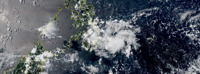
Tropical Storm "Crising" at 06:40 UTC on May 12, 2021. Credit: JMA/Himawari-8, RAMMB/CIRA, TW
Gale-force winds are expected in localities under Tropical Cyclone Wind Signal (TCWS) #2 and strong breeze to near gale conditions over the localities where Tropical Cyclone Wind Signal #1 is in effect, especially in the coastal and mountainous areas of these localities.
Over the next 24 hours, moderate to rough seas will be experienced over the eastern seaboard of Mindanao (1.2 to 3.0 m / 3.9 to 9.8 feet). Mariners of small seacrafts are advised not to venture out over these waters. Inexperienced mariners of these vessels should avoid navigating in these conditions.
On the forecast track, Crising will move westward or west-northwestward and is likely to make landfall over the Davao Oriental-Surigao del Sur area between tonight and tomorrow morning (LT), May 14.

Slight intensification is likely and Crising is forecast to remain a tropical storm prior to landfall.
Throughout tomorrow, May 14, Crising is forecast to weaken into a tropical depression as it traverses the rugged landmass of Mindanao and will emerge over the Sulu Sea on Saturday morning (LT), May 15.
The storm is forecast to weaken into a remnant low on Sunday, May 16 while passing over Palawan and dissipate shortly afterward.
Featured image: Tropical Storm "Crising" at 06:40 UTC on May 12, 2021. Credit: JMA/Himawari-8, RAMMB/CIRA, TW
Commenting rules and guidelines
We value the thoughts and opinions of our readers and welcome healthy discussions on our website. In order to maintain a respectful and positive community, we ask that all commenters follow these rules:
We reserve the right to remove any comments that violate these rules. By commenting on our website, you agree to abide by these guidelines. Thank you for helping to create a positive and welcoming environment for all.