Severe flash flooding after exceptionally heavy rains hit Pennsylvania, U.S.
Slow-moving thunderstorms dropped exceptionally heavy rains in just a couple of hours over parts of Pennsylvania and New Jersey on Monday, July 12, 2021, shutting down highways, prompting water rescues, and forcing authorities to issue flash flood emergencies.
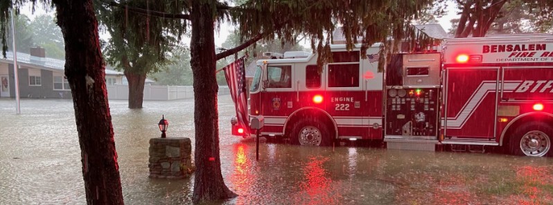
AccuWeather Senior Meteorologist Dave Bowers said slow-moving thunderstorms, fueled by a nearly stationary front, tropical moisture and warm weather, dropped astounding amounts of rain in a couple of hours, causing serious flash flooding late Monday afternoon (LT).
The National Weather Service (NWS) office of Mount Holly, NJ placed parts of Bucks County near Philadelphia and Burlington County, New Jersey, under Flash Flood Emergency at 17:00 LT. Areas under emergency included Levittown and Croydon, Pennsylvania, and Burlington, New Jersey.
This is where most of the rain fell, with Croydon receiving over 254 mm (10 inches) of rainfall, Bristol Township, PA 250.19 mm (9.85 inches), Bristol (Borough), PA 220.72 mm (8.69 inches), West Bristol, PA 207.77 mm (8.18 inches), and Florence, NJ 193.80 mm (7.63 inches).


The active summertime pattern of mainly afternoon/evening intense thunderstorms with heavy downpours will continue to make weather headlines through the middle of the week, NWS forecaster Hamrick noted on July 13. This especially holds true for portions of the Northeast U.S., Florida, and the Northern Plains to the Upper Midwest.
A quasi-stationary frontal boundary will be nearly anchored in place across New York and southern New England, and this in combination with multiple mid-upper level impulses will fuel additional rounds of storms with high rainfall rates, and any storms that develop will have the potential to produce flash flooding.
The threat for flooding will be even greater across those areas that have observed well above normal rainfall over the past few days. Afternoon and evening showers and storms are expected to be in place across the Four Corners region, and especially southern Arizona and New Mexico, as the southwest monsoon kicks into high gear.
Given relatively weak steering flow aloft, many of these storms will likely be slow-moving and result in flash flooding for canyons, across burn scars, and other vulnerable areas.
Showers and storms are also expected to increase across portions of the Dakotas and extending eastward across much of the Upper Midwest as a cold front intercepts a moist and unstable airmass ahead of it. Training of convection may also lead to flooding concerns for this region, mainly on Wednesday.
Featured image: Bensalem Fire Rescue
Commenting rules and guidelines
We value the thoughts and opinions of our readers and welcome healthy discussions on our website. In order to maintain a respectful and positive community, we ask that all commenters follow these rules.