Typhoon “Conson” (Jolina) makes landfall in the Philippines, moving toward capital Manila
Tropical Storm "Conson" — known as Jolina in the Philippines — formed at 06:00 UTC on September 6, 2021, as the 13th named storm of the 2021 Pacific typhoon season.
At 15:00 UTC (23:00 Philippine Standard Time) on September 6, the Japan Meteorological Agency (JMA) upgraded it to a Severe Tropical Storm.
According to the Philippine Atmospheric, Geophysical and Astronomical Services Administration (PAGASA), the system rapidly intensified into a typhoon at that time and made its first landfall in Hernani, Eastern Samar with maximum sustained winds of 120 km/h (75 mph) near the center, and gusts of up to 150 km/h (95 mph). It was moving WNW at 15 km/h (9 mph).
The storm made another landfall at 18:30 UTC (02:30 LT, September 7) in Daram, Samar, and another one at 19:40 UTC (03:40 LST) in Santo Niño, Samar. At 22:30 UTC (06:30 LT) Conson made the fourth landfall in Almagro, Samar.

In the next 24 hours, heavy to intense with at times torrential rains are forecast over Masbate, Leyte, Biliran, Samar, Northern Samar, Sorsogon, Albay, Catanduanes, Camarines provinces, Southern Quezon, Romblon, and Marinduque, PAGASA said.1
Moderate to heavy with at times intense rains are expected over Mindoro Provinces and the rest of CALABARZON and Visayas.
Under these conditions, scattered to widespread flooding (including flash floods) and rain-induced landslides are possible especially in areas that are highly or very highly susceptible to these hazard as identified in hazard maps.

Damaging gale-force to storm-force winds are likely to occur within any of the areas where TCWS #2 is in effect. This may bring generally light to moderate damage to structures and vegetation.
Strong winds (strong breeze to near gale conditions) with occasional gusts will be experienced in areas where Tropical Cyclone Wind Signal (TCWS) #1 is in effect. This may result with up to very light damage to structures and vegetation.
The threat of coastal inundation due to storm surge of up to 0.5 – 1 m (1.6 – 3.3 feet) continues for several coastal localities of Biliran, Sorsogon, Samar, and Masbate which may pose threat to life and property. In addition, coastal areas of localities under TCWS, especially those at #2 and #3 may experience coastal flooding due to hazardous surf conditions.
The system will bring rough to very rough seas (2.5 to 5 m / 8 to 16 feet) over the seaboards of areas where TCWS #2 and #3 are in effect. Sea travel is risky for all types of seacrafts over these waters. Mariners without the proper experience should immediately seek safe harbor.
Moderate to rough seas (1.2 to 2.8 m / 4 – 9 feet) will be experienced over the seaboards of areas where TCWS #1 is in effect, the remaining seaboards of Visayas, and the northern eastern seaboards of Mindanao.
Mariners of small seacrafts are advised to take precautionary measures when venturing out to sea. Inexperienced mariners should avoid navigating in these conditions.

Conson weakened into a severe tropical storm at 03:00 UTC (11:00 LT) on September 7, PAGASA said.1
In the next 12 hours, it is expected to continue moving generally WNW traversing Masbate and Ragay Gulf before making another landfall in the vicinity of southeastern Quezon tonight or tomorrow early morning (LT).
Throughout the remainder of tomorrow and into Thursday morning, the tropical cyclone is forecast to cross Central Luzon (roughly to the east and north of Metro Manila).
Frictional effects during its traverse of Luzon landmass will weaken the system down to tropical storm category.
The storm is forecast to emerge over the West Philippine Sea before 04:00 UTC on September 9.
Re-intensification is forecast to occur beginning on Thursday afternoon as the tropical cyclone moves WNW over the West Philippine Sea towards the southern China – northern Vietnam area.

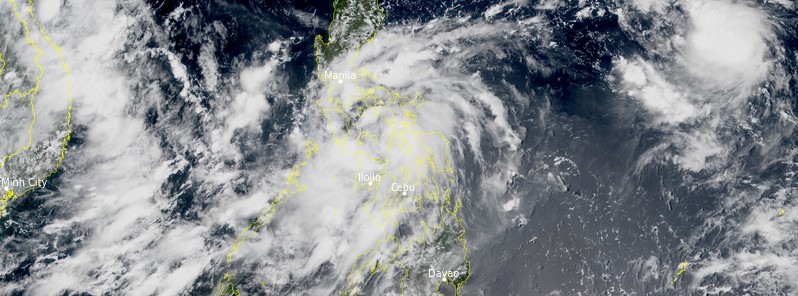
Tropical Storm "Conson" at 04:20 UTC on September 6, 2021. Credit: NOAA/GOES-East, RAMMB/CIRA, TW
At 03:00 UTC September 7, the center of Tropical Storm "Conson" (Jolina) was located about 467 km (290 miles) southeast of Manila, Philippines.
Its maximum 10-minute sustained winds were 85 km/h (50 mph), with gusts up to 120 km/h (75 mph). Maximum 1-minute sustained winds were 100 km/h (65 mph). The minimum central barometric pressure was 998 hPa and the system was moving WNW at 15 km/h (9 mph).2

Tropical Storm "Conson" JTWC forecast track at 03:00 UTC on September 7, 2021. Credit: JTWC
Meanwhile, another tropical cyclone — Chanthu — formed east of the Philippines as Conson approached the coastline.
Chanthu formed at 07:00 UTC on September 6 and was located about 1 515 km (941 miles) southeast of Kadena Air Base, Japan at 03:00 UTC on September 7.3
The system had maximum 10-minute sustained winds of 85 km/h (50 mph) at the time, with gusts up to 120 km/h (75 mph). Maximum 1-minute sustained winds were 120 km/h (75 mph). The minimum central barometric pressure was 994 hPa and the system was moving WNW at 15 km/h (9 mph).
The current forecast track takes it north of the Philippines while intensifying and possibly into southern Taiwan and China on September 12.

Tropical Storm "Conson" JTWC forecast track at 03:00 UTC on September 7, 2021. Credit: JTWC
References:
1 TROPICAL CYCLONE BULLETIN NO. 10 Severe Tropical Storm “JOLINA” (CONSON) Issued at 2:00 PM, 7 September 2021 – PAGASA
2 Tropical Storm 18W (Conson) Warning #05 Issued at 07/0300Z – JTWC
3 Tropical Storm 19W (Chanthu) Warning #04 Issued at 07/0300Z – JTWC
Featured image: Tropical Storm "Conson" at 04:20 UTC on September 6, 2021. Credit: NOAA/GOES-East, RAMMB/CIRA, TW
Commenting rules and guidelines
We value the thoughts and opinions of our readers and welcome healthy discussions on our website. In order to maintain a respectful and positive community, we ask that all commenters follow these rules:
We reserve the right to remove any comments that violate these rules. By commenting on our website, you agree to abide by these guidelines. Thank you for helping to create a positive and welcoming environment for all.