Typhoon “Vamco” strikes the Philippines, leaving a massive trail of destruction
Typhoon "Vamco" — known locally as the Ulysses — struck the Philippines on November 11, 2020, with maximum sustained winds of 155 km/h (96 mph) and gusts to 205 km/h (127 mph). This is the 21st named storm to hit the country this year and the 4th in the past month– after Molave, Etau, and Goni (super typhoon). It is also the 22nd named storm of the 2020 Pacific typhoon season and the 10th typhoon.
Vamco left a massive trail of destruction, millions without power, at least two people dead, 4 missing, and nearly 200 000 displaced.
Bicol, the worst affected by Super Typhoon "Goni," was the first to feel Vamco's powerful winds and rain. Many people there remain without power with only limited or no telecommunication services after Goni.
The storm then battered Calabarzon, Central Luzon, and Metro Manila, unleashing powerful winds and torrential rain that left neighborhoods submerged and people appealing for aid and rescue, the Rappler reports.
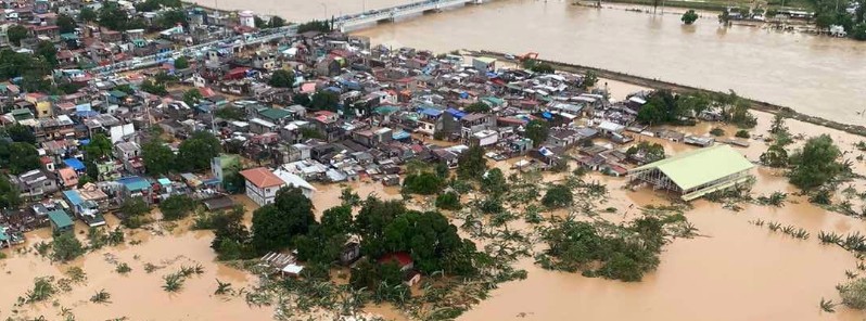
Social media sites were flooded with pictures of inundated villages with rooftops barely peering through the water’s surface.
Metro Manila woke up to major flooding, described as the worst in years. Authorities used boats to reach people stranded on rooftops or trapped in their homes.
Even some areas that were historically not flooded, such as the City Hall, were now submerged, PhilStar reported.
More than 3.8 million customers in and around Manila were left without power.

Typhoon "Vamco" at 13:30 UTC on November 11, 2020. Credit: JMA/Himawari-8, RAMMB/CIRA

Typhoon "Vamco" at 16:40 UTC on November 11, 2020. Credit: JMA/Himawari-8, RAMMB/CIRA
The Armed Forces of the Philippines (AFP) has dispatched all of its disaster response units to affected areas, the Philippine News Agency (PNA) said, adding that AFP is monitoring the situation along the Marikina River that is experiencing heavy flooding.
"Evacuation is ongoing, with the Naval Task Group of the JTF-NCR joining city disaster risk and reduction units with their rubber boats, trucks, and personnel," AFP Chief of Staff, Gen. Gilbert Gapay, said in a statement Thursday.

Roughly 40 000 homes had been either fully or partially submerged in Marikina City, according to Mayor Marcelino Teodoro.
Teodoro described the situation as 'overwhelming' and the worst since Typhoon "Ketsana" (Ondoy) flooded large swathes of Manila in 2009. Ketsana affected nearly 900 000 people and is considered the most devastating typhoon to hit Manila, surpassing Typhoon "Patsy" (Yoling) in 1970. It left at least 464 people dead across the country.
The Marikina River rose to 21.8 m (71.5 feet) by 09:04 LT on November 12, which is the highest water level seen since 2009.
President Rodrigo Duterte on Thursday assured that the national government will provide relief, rescue, and assistance to severely affected families, adding that no one will be left behind.
Flight operations resumed at the Ninoy Aquino International Airport (NAIA) at 08:00 LT on November 12, after authorities announced suspending flight operations from 00:00 LT on November 11.
"We were open at 8 a.m. International flights already started check-in. PAL (Philippine Airlines) domestic has only one flight today, which is bound for Cebu later at 4 p.m.," Manila International Airport Authority (MIAA) Public Affairs Department's officer-in-charge Consuelo Bungag told PNA.
Residents in the Pollilo Islands, Camarines Norte, and in Central Luzon were forced to evacuate on November 10, a day before Vamco made landfall, as well as more than 12 000 in Bicol. However, reports say many of them refused to leave.
Over 2 071 passengers were stranded in ports in multiple regions of Luzon as sea conditions worsened.
At 08:00 UTC on November 12, Vamco's center was located about 200 km (124 miles) west of Iba, Zambales. It had maximum sustained winds of 120 km/h (75 mph) and gusts to 150 km/h (95 mph), according to PAGASA.
It was moving W at 25 km/h (15 mph).

Typhoon "Vamco" at 08:00 UTC on November 12, 2020. Credit: JMA/Himawari-8, RAMMB/CIRA
Moderate to heavy rains are expected until tonight (LT) over Cordillera Administrative Region, the eastern portions of Cagayan and Isabela, Zambales, Bataan, Aurora, Cavite, the western portion of Batangas, and Occidental Mindoro including Lubang Island.
Light to moderate with at times heavy rains are expected over Western Visayas, Samar Provinces, Metro Manila, and the rest of Luzon.
Flooding (including flash floods), rain-induced landslides, and sediment-laden streamflows (i.e. lahar) may occur during heavy or prolonged rainfall especially in areas that are highly or very highly susceptible to these hazards and/or those that received significant antecedent rainfall.
Over the next 24 hours, the combined effects of Typhoon "Vamco" and the surge of the Northeast Monsoon will bring rough to very rough seas (2.5 to 6.0 m / 8 to 20 feet) over the seaboards of areas under TCWS, Northern Luzon, and Occidental Mindoro and the western seaboards of Batangas and Palawan including Calamian and Kalayaan Islands. Sea travel is risky for all types of vessels over these waters.
Moderate to rough seas (1.5 to 2.5 m / 5 – 8 feet) will be experienced over the eastern seaboards of Central and Southern Luzon, the Visayas, and Mindanao, the seaboards of Cuyo Islands, and the western seaboard of Panay Island.
Mariners of small seacrafts are advised to take precautionary measures when venturing out to sea. Inexperienced mariners should avoid navigating in these conditions, PAGASA said.
The typhoon is expected to intensify over the next 24 hours and then weaken as it moves toward landfall in Central Vietnam.

Update
November 13
A total od 170 561 people in 811 barangays in Regions II, CALABARAZON, MIMAROPA, V, NCR, and CAR were affected by the storm, of which 74 721 are in 825 evacuation centers, NDRRMC said in an update released at 08:00 LT (00:00 UTC) on November 13.
At this time, there are 12 confirmed deaths, 8 people injured and 14 missing in Regions II, CALABARZON, V, and CAR.
A total of 181 road sections and 62 bridges were affected by foods, mudflows, landslides, swollen rivers and soil/rock collapse. Of those, 161 road sections and 58 bridges are not passable.
Featured image: Senator Bong Go
The inevitable is becoming undeniable. We all need to be prepared because no one is going to look out for us but ourselves. I’d like to invite you all to join me at “BugOutHive” to participate and discuss means of survival.