Tropical Storm “Kay” – Considerable flooding possible in the Southwest U.S.

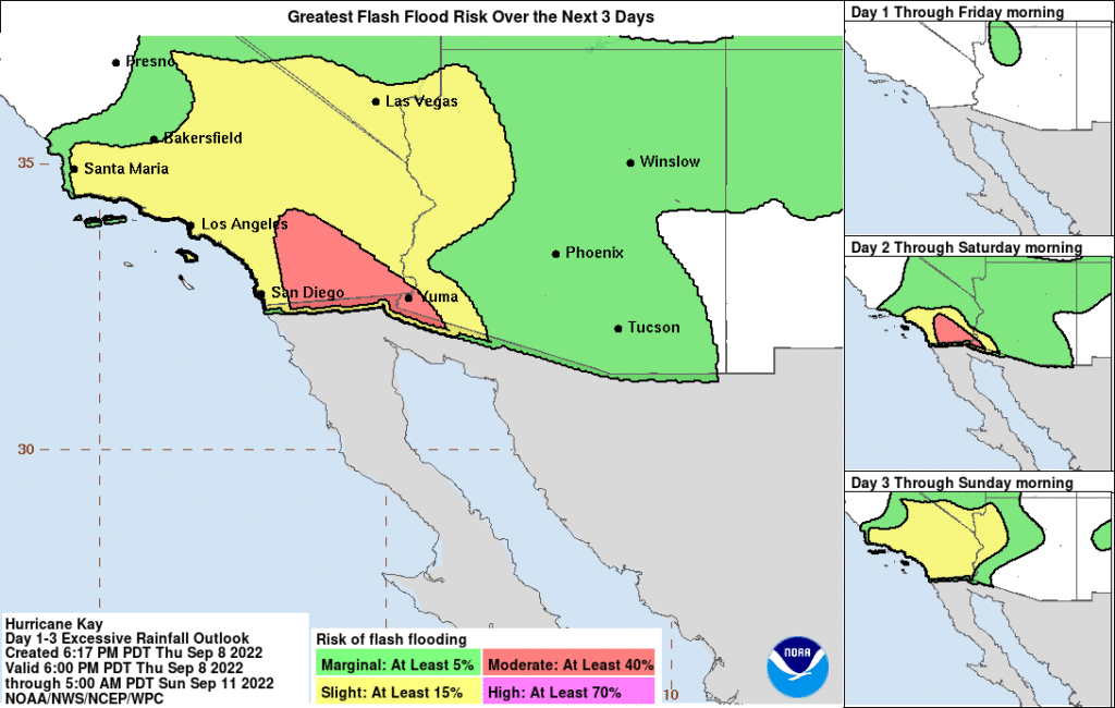
Tropical Storm “Kay” is moving parallel to the western coast of the Baja California peninsula, bringing heavy rains and flooding to Mexico. The moisture produced by the storm may also produce heavy rain and the potential for considerable flash flooding in the Southwest U.S., especially in the Peninsular ranges.
At 06:00 UTC on September 9, the center of Tropical Storm “Kay” was located about 135 km (85 miles) NNW of Punta Eugenia, Mexico and 430 km (270 miles) SSE of San Diego, California, U.S., according to the National Hurricane Center (NHC).1
The storm had maximum sustained winds of 100 km/h (65 mph), minimum central pressure of 987 hPa, and was moving NNW at 22 km/h (14 mph).
A slower northwestward to west-northwestward motion is forecast to begin today and continue into Saturday, September 10, followed by a turn to the west by late Saturday (LT).
On the forecast track, the center of Kay will pass near or west of the northwest coast of the Baja California peninsula later today.
Additional weakening is forecast during the next couple of days, and Kay is expected to degenerate into a remnant low by late Saturday.
However, the tropical cyclone will continue dropping heavy rain to the region, causing flooding. In addition, the moisture produced by the system may produce heavy rain and potential for considerable flash flooding in the Southwest U.S., especially in the Peninsular ranges.
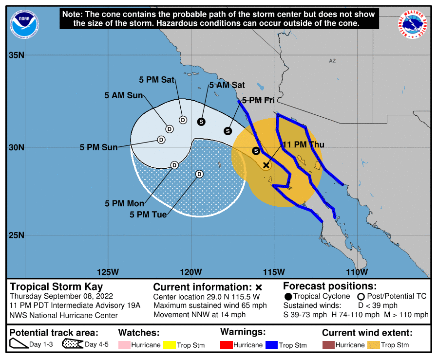
A Tropical Storm Warning is in effect for Puerto San Andresito northward along the west coast of the Baja California peninsula to the U.S./Mexico border; and for areas north of Loreto northward along the east coast of the Baja California peninsula and then southward to Guaymas in mainland Mexico.
Tropical storm conditions are occurring over portions of the Tropical Storm Warning area and are forecast to spread northward today.
Strong winds not directly associated with Kay’s core wind field are expected across portions of southern California and extreme southwestern Arizona beginning on Friday.
A dangerous storm surge is likely to produce coastal flooding in areas of onshore winds along the west coast of the central Baja California peninsula of Mexico. The surge will be accompanied by large and destructive waves.
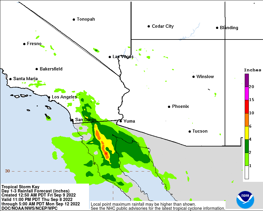
Kay is expected to produce the following rainfall totals through Saturday:
- Baja California Peninsula: 150 – 250 mm (6 to 10 inches), isolated maxima of 380 mm (15 inches).
- Northwest Mainland Mexico: 50 – 100 mm (2 to 4 inches), isolated maxima of 150 mm (6 inches).
- Southernmost California: 75 – 125 mm (3 to 5 inches) with isolated maxima of 200 mm (8 inches).
- Southwest Arizona: 25 – 50 mm (1 to 2 inches) with isolated maxima of 75 mm (3 inches).
These rainfall amounts could lead to flash flooding, with landslides possible across mountainous areas of Mexico.
Swells generated by Kay will continue to affect portions of the coast of southwestern Mexico during the next day or so.
Large swells are expected to spread northward along the Baja California peninsula coast, into the Gulf of California, and to southern California during the next couple of days.
These swells will likely cause life-threatening surf and rip current conditions.
References:
1 Tropical Storm Kay Intermediate Advisory Number 19A – NWS National Hurricane Center Miami FL – 1100 PM PDT Thu Sep 08 2022
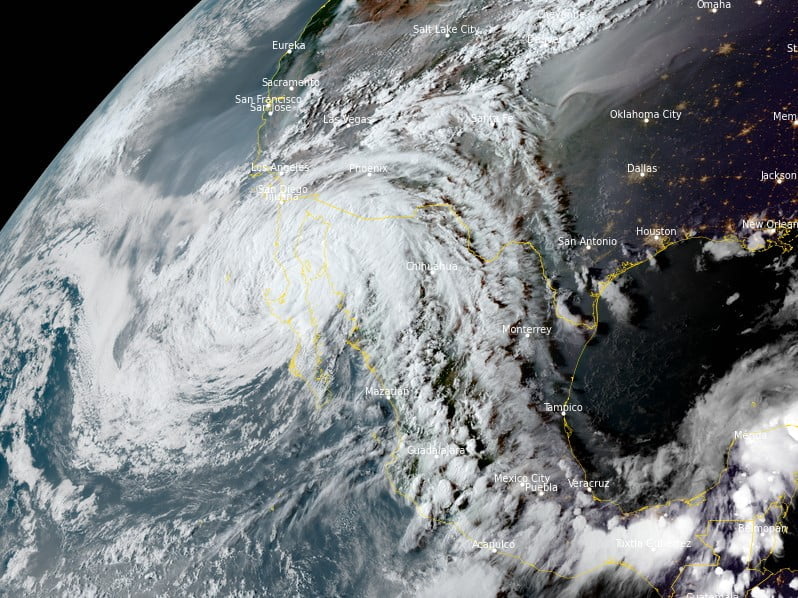
Featured image: Tropical Storm “Kay” at 23:50 UTC on September 8, 2022. Credit: NOAA/GOES-East, RAMMB/CIRA, The Watchers
Commenting rules and guidelines
We value the thoughts and opinions of our readers and welcome healthy discussions on our website. In order to maintain a respectful and positive community, we ask that all commenters follow these rules:
We reserve the right to remove any comments that violate these rules. By commenting on our website, you agree to abide by these guidelines. Thank you for helping to create a positive and welcoming environment for all.