


Geologists are using drones to help extract more resources from the North Sea, using the latest visual technologies to identify oil-bearing rocks.
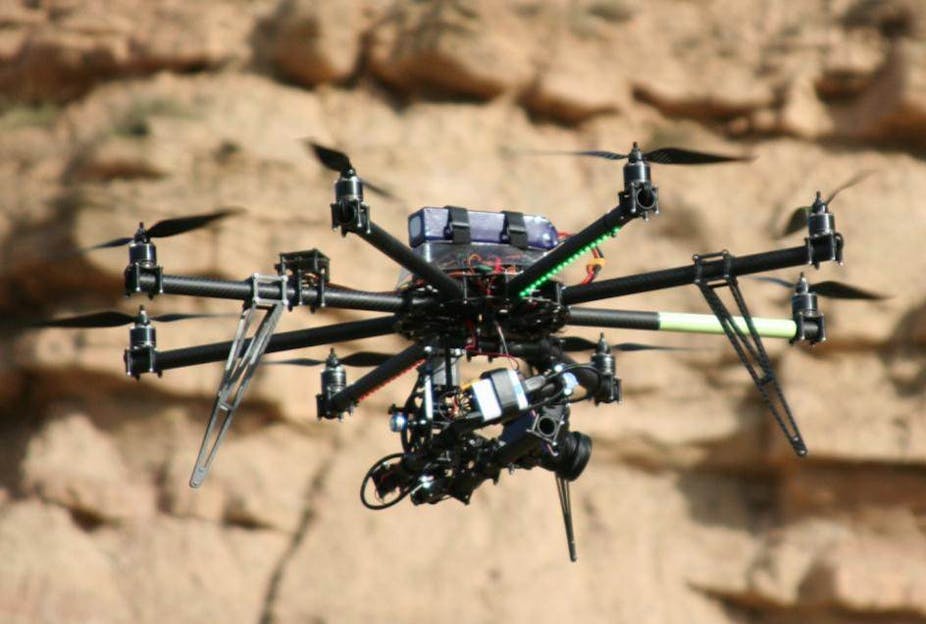
Using an eight-rotor, camera-equipped “octocopter” drone to record rock faces in minute detail, the research team from the Universities of Aberdeen and Bergen in Norway are creating a “Google Earth for geologists”.
John Howell, Aberdeen’s chair of geology and petroleum geology, explained that while two boreholes drilled a mile apart can provide rock samples to examine, the nature of the rock between remains unknown – and could be very different.
“We have no real understanding of what’s in between the wells if they are a substantial distance apart,” he said. “And the 15cm strip from a borehole doesn’t allow us to analyse the rock at the resolution we’d like.”
Instead, a drone scans and records the rocks of exposed cliff faces, which provides geologists and petroleum geochemists with highly detailed images that can help them identify the type of rocks likely to have formed oil reservoirs.
The project, called SAFARI, generates not just pictures, but accurate 3D models of entire rock faces. The current drone uses twin cameras to take pictures that are offset at slightly different angles and perspectives (similar to techniques used in 3D cinema). Then, using a single point of reference on each, the photos are combined using computer software to triangulate a 3D-projection from a flat, two dimensional image.

“This technique, called stereophotogrammetry, is actually quite old, but digital cameras and advances in computing power has made it much more useful,” Howell said. “We can produce accurate models with detail down to the centimetre range.”
The SAFARI database contains detailed 3D models of rock outcrops from many parts of the world. But what use is an accurate model of a rock in, say, a Spanish desert to prospectors looking for oil miles below the North Sea?
“What we’re interested in is reservoirs of oil under the sea,” he said. “We have to interpret what we know of the geology and find comparable rock above ground to examine closely.
"For example, oil-bearing rocks were laid down hundreds of millions of years ago, in the Triassic period. But at that time, the North Sea was a desert.”
“So I could go to somewhere like Spain, which has where nice examples of rocks also laid down in a desert, and interpret those for the sort of features we’re hoping to find.”
Indiana Drones?
Drone-based surveying has been useful to other fields too, such as archaeology. Dr Gabor Thomas, professor of medieval archaeology at Reading University, said his work had been “revolutionised”.
“You get a lot more accuracy and flexibility compared to other techniques, such as cameras on long poles, or kites,” he said. “During our excavation of an Anglo-Saxon palace in Lyminge in Kent last year, the operator overflew the site and we had a detailed 3D model within about half an hour.”
Paul Baggaley, geoservices director for Wessex Archaeology, said the use of aerial photographic surveys in archaeology went back 100 years. “But the detail, the resolution isn’t there,” he said. “With the photogrammetry recorded from drones, we can pick up objects 10cm wide.”
While Google Earth offers only five to ten-year-old photographs, drones can deliver up-to-date imagery for developers, or an opportunity for archaeologists to survey the land without the expense of a field team on the ground.
Surveyor’s tools, from pencils to lasers
These cutting-edge techniques are the latest in survey methods developed by geologists over 200 years.
In the 1815, British geologist William Smith produced the first of his Maps that Changed the World from his systematic surveying using only paper and pencil.
With the advent of photography, geologists could record details much more easily than by making painstaking drawings. “This is what I’d do in the 1990s; we’d take photos of a cliff section, develop the photos and tape them all together into a montage and make an interpretation of that,” Professor Howell said. “But you lose a lot of information this way, as it flattens everything into a single plane.”
A real revolution came with Lidar at the turn of the century, which uses a laser to scan objects tens of thousands of times per second, recording millions of points with which to create a detailed, wireframe model. “Then we’d take photos too and overlay them over the structure to create a 3D model, like Google Earth,” Howell said.
With the laser mounted on a helicopter, the team could cover 30km of cliff in an hour, rather than 500m per day. But at £10,000, the cost of a drone and equipment was equivalent to hiring a helicopter for only a few hours. This made it an obvious next step, but meant swapping lasers for the stereoscopic cameras the team currently use – the drone can only carry 1.5Kg.
So will SAFARI become a complete Google Earth for geologists? “Perhaps – but not the whole Earth,” Howell said, “to geologists, most of it isn’t that interesting.”