Sustainable Use of Groundwater Resources in the Transboundary Aquifers of the Five Central Asian Countries: Challenges and Perspectives

 , , , ,
Abstract
:1. Introduction
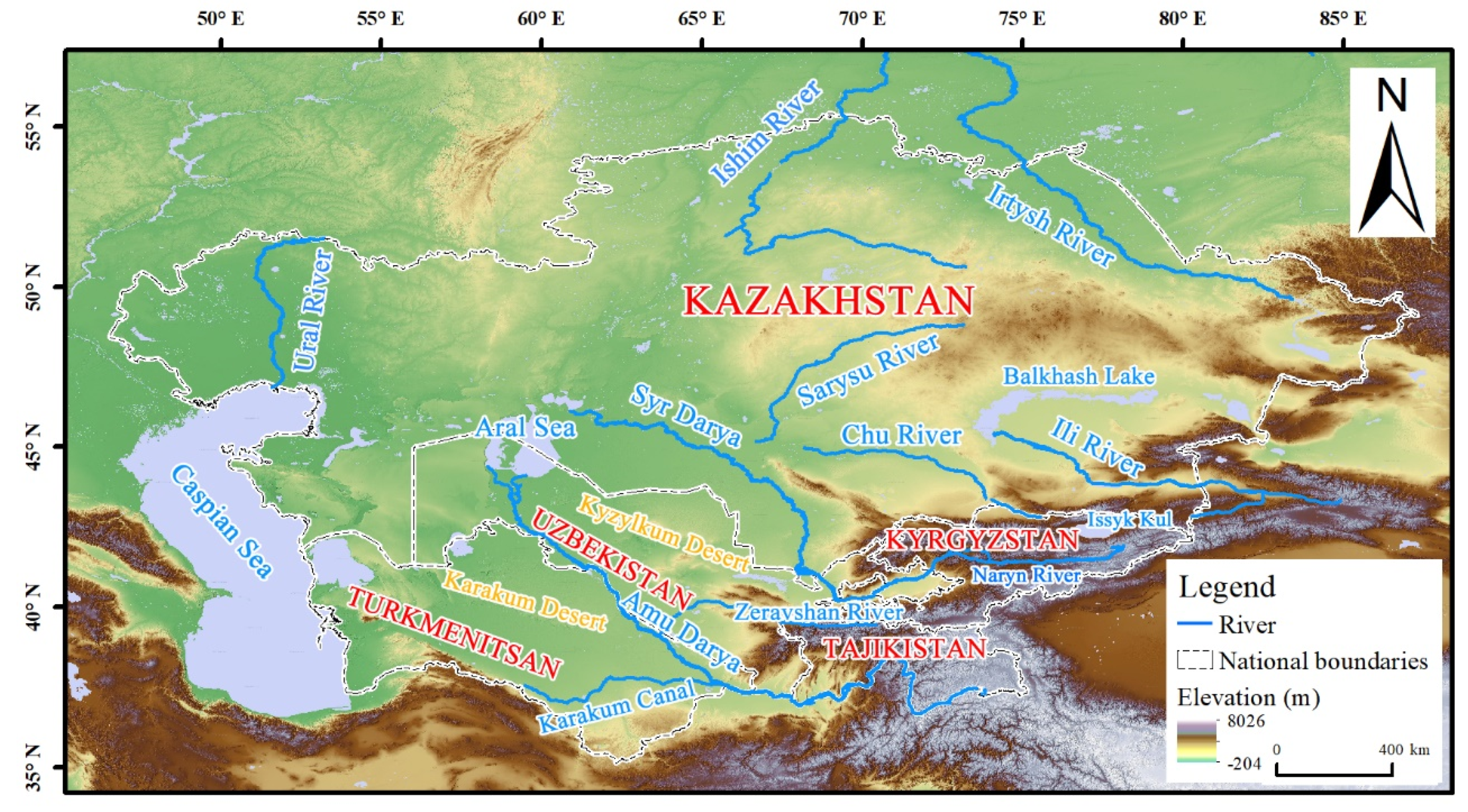
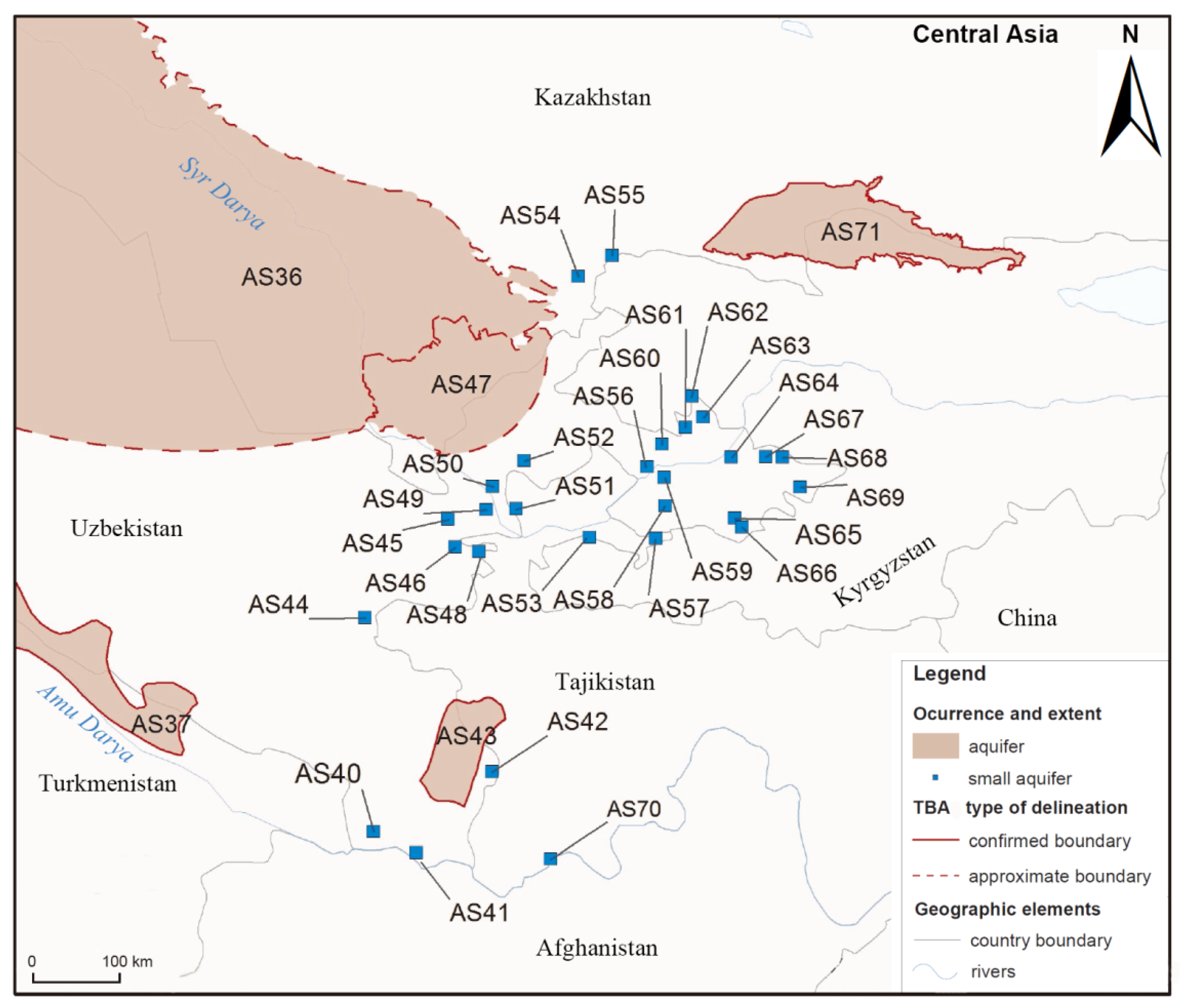
2. Study Area
3. Methodology
4. Groundwater and its Utilization in TBAs
4.1. Groundwater Resources in TBAs
4.2. Groundwater Resource Utilization of TBAs in the Aral Sea Basin
5. Challenges Associated with Groundwater Exploitation in TBAs
5.1. Groundwater Overexploitation and Water Level Decline
5.2. Groundwater Pollution
6. Comparative Assessment of the TBAs in Central Asia
6.1. Issues of Scale and Number
6.2. Groundwater Indicators
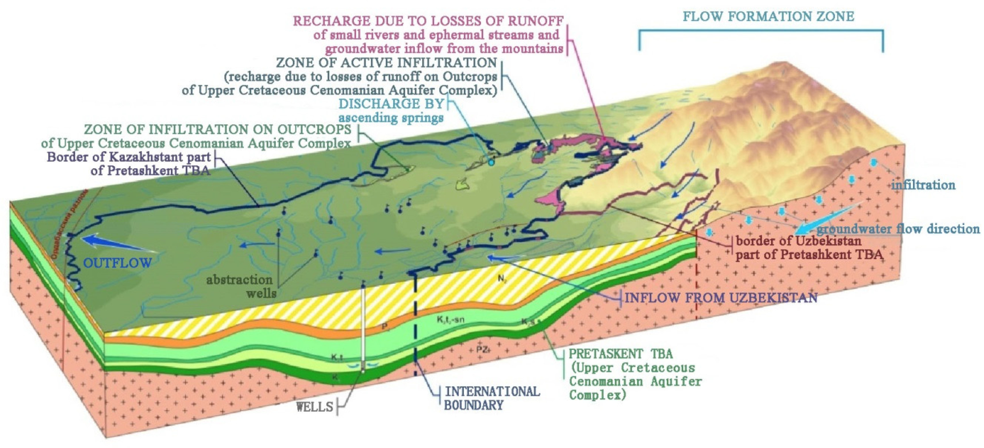
6.3. Case Studies
7. Strategies for the Further Development of Water Resources in TBAs
7.1. Reasonable and Equitable use of Groundwater Resources
7.2. Ecological Protection of Transboundary Aquifers
7.3. Strengthening Dialogue and International Cooperation
8. Concluding Remarks
Author Contributions
Funding
Acknowledgments
Conflicts of Interest
References
- International Groundwater Resources Assessment Centre. Available online: https://www.un-igrac.org/who-we-are (accessed on 10 June 2020).
- Zhong, H.; Bi, S. Management status of transboundary aquifer and enlightenment. China Water Resour. 2011, 19, 64–66. (In Chinese) [Google Scholar]
- UNESCO-IGRAC. Transboundary Aquifers of the World Map. Available online: https://www.un-igrac.org/ggis/transboundary-aquifers-world-map (accessed on 10 June 2020).
- Zhang, F.; Cheng, Y.; Dong, H.; Huang, Z. Asian Groundwater and Environment; Science Press: Beijing, China, 2019. (In Chinese) [Google Scholar]
- Gorelick, S.M.; Zheng, C. Global change and the groundwater management challenge. Water Resour. Res. 2015, 51, 3031–3051. [Google Scholar] [CrossRef]
- Puri, S.; Aureli, A. Transboundary aquifers: A global program to assess, evaluate, and develop policy. Ground Water 2005, 43, 661–668. [Google Scholar] [CrossRef] [PubMed]
- Herbert, C.; Doll, P. Global Assessment of Current and Future Groundwater Stress with a Focus on Transboundary Aquifers. Water Resour. Res. 2019, 55, 4760–4784. [Google Scholar] [CrossRef]
- Lee, E.; Jayakumar, R.; Shrestha, S.; Han, Z. Assessment of transboundary aquifer resources in Asia: Status and progress towards sustainable groundwater management. J. Hydrol. Reg. Stud. 2018, 20, 103–115. [Google Scholar] [CrossRef]
- Eckstein, Y.; Eckstein, G.E. Transboundary Aquifers: Conceptual Models for Development of International Law. Groundw. Intensive Use 2005, 43, 679–690. [Google Scholar] [CrossRef] [Green Version]
- Pétré, M.A.; Rivera, A.; Lefebvre, R. Numerical modeling of a regional groundwater flow system to assess groundwater storage loss, capture and sustainable exploitation of the transboundary Milk River Aquifer (Canada–USA). J. Hydrol. 2019, 575, 656–670. [Google Scholar] [CrossRef]
- Lesser, L.E.; Mahlknecht, J.; López-Pérez, M. Long-term hydrodynamic effects of the All-American Canal lining in an arid transboundary multilayer aquifer: Mexicali Valley in north-western Mexico. Environ. Earth Sci. 2019, 78, 504. [Google Scholar] [CrossRef] [Green Version]
- He, Y. China’s Transboundary Groundwater Cooperation in the Context of Emerging Transboundary Aquifer Law. Groundwater 2017, 55, 489–494. [Google Scholar] [CrossRef]
- Zeitoun, M.; Goulden, M.; Tickner, D. Current and future challenges facing transboundary river basin management. Wiley Interdiscip. Rev. Clim. Chang. 2013, 4, 331–349. [Google Scholar] [CrossRef]
- Davies, J.; Robins, N.S.; Farr, J.; Sorensen, J.; Beetlestone, P.; Cobbing, J.E. Identifying transboundary aquifers in need of international resource management in the Southern African Development Community region. Hydrogeol. J. 2013, 21, 321–330. [Google Scholar] [CrossRef] [Green Version]
- Kokimova, A. Developing a Transboundary Groundwater Model in the Water Scarce Region of Central Asia: A Case Study of the Pretashkent Transboundary Aquifer. Master’s Thesis, IHE Delft, Delft, The Netherlands, 2019. [Google Scholar]
- Held, I.M.; Soden, B.J. Robust Responses of the Hydrological Cycle to Global Warming. J. Clim. 2006, 19, 5686–5699. [Google Scholar] [CrossRef]
- Fallatah, O.A.; Ahmed, M.; Save, H.; Akanda, A.S. Quantifying temporal variations in water resources of a vulnerable middle eastern transboundary aquifer system. Hydrol. Process. 2017, 31, 4081–4091. [Google Scholar] [CrossRef]
- Gaye, C.B.; Tindimugaya, C. Review: Challenges and opportunities for sustainable groundwater management in Africa. Hydrogeol. J. 2019, 27, 1099–1110. [Google Scholar] [CrossRef]
- Howard, K.W.F.; Howard, K.K. The new “Silk Road Economic Belt” as a threat to the sustainable management of Central Asia’s transboundary water resources. Environ. Earth Sci. 2016, 75, 976. [Google Scholar] [CrossRef]
- Yu, Y.; Pi, Y.; Yu, X.; Ta, Z.; Sun, L.; Disse, M.; Zeng, F.; Li, Y.; Chen, X.; Yu, R. Climate change, water resources and sustainable development in the arid and semi-arid lands of Central Asia in the past 30 years. J. Arid Land 2019, 11, 1–14. [Google Scholar] [CrossRef] [Green Version]
- Abdullaev, I.; Rakhmatullaev, S. Transformation of water management in Central Asia: From State-centric, hydraulic mission to socio-political control. Environ. Earth Sci. 2015, 73, 849–861. [Google Scholar] [CrossRef]
- Yao, H.; Zhou, H. Research on issues of transboundary water resources in Central Asia. Resour. Sci. 2014, 36, 1175–1182. (In Chinese) [Google Scholar]
- Malyar, I. Transboundary Water Institutions in Developing Countries: A Case Study in Afghanistan. Master’s Thesis, Oregon State University, Corvallis, OR, USA, 2016. [Google Scholar]
- Pak, M. International river basin management in the face of change: Syr Darya Basin case study. Ph.D. Thesis, Oregon State University, Corvallis, OR, USA, 2014. [Google Scholar]
- Li, X.; Zhang, L.; Guo, H.; Fu, W.; Lu, L.; Qiu, Y.; Wang, X.; Jia, G. Space recognition of eco-environment global change response of arid and semi-arid region of the Silk Road economic belt. Bull. Chin. Acad. Sci. 2016, 31, 559–566. (In Chinese) [Google Scholar]
- Ruan, H.; Yu, J. Changes in land cover and evapotranspiration in the five central Asian countries from 1992 to 2015. Acta Geogr. Sin. 2019, 74, 1292–1304. (In Chinese) [Google Scholar]
- Hu, R.; Jiang, F.; Wang, Y.; Li, J.; Li, Y.; Abdimijit, A.; Luo, G.; Zhang, J. Arid ecological and geographical conditions in five countries of central Asia. Arid Zone Res. 2014, 31, 1–12. (In Chinese) [Google Scholar]
- Margat, J.; Gun, J.V.D. Groundwater around the World: A Geographic Synopsis; CRC Press/Balkema: London, UK, 2013. [Google Scholar]
- Yang, S.; Yu, X.; Ding, J.; Zhang, F.; Wang, F.; Ma, Y. A review of water issues research in Central Asia. Acta Geogr. Sin. 2017, 72, 79–93. (In Chinese) [Google Scholar]
- UNESCO-IHP and UNEP. Transboundary Aquifer Information Sheet. Available online: https://apps.geodan.nl/igrac/ggis-viewer/region_information (accessed on 10 June 2020).
- Heinz, V.A.; Sultanhodzhaev, A.N. Hydrogeology of USSR; Mavlyanov, G.A., Lange, O.K., Eds.; Nedra: Moscow, Russia, 1971; Volume XXXIX, pp. 132–153. [Google Scholar]
- UNECE. Second Assessment of Transboundary Rivers, Lakes and Groundwaters, United Nations New York and Geneva. Available online: https://www.unece.org/index.php?id=26343 (accessed on 10 June 2020).
- Podolny, O.V.; Skopintsev, I.B.; Alibekova, V.S.; Aureli, A. Pretashkent transboundary aquifer in central Asia (research project GGRETA). In Proceedings of the Water Resources of Central Asia and Their Use, Almaty, Kazakhstan, 22–24 September 2016; pp. 330–339. (In Russian). [Google Scholar]
- UNESCO-IHP Groundwater Portal. Pretashkent Aquifer: GGRETA Assessment Report Pretashkent Aquifer. Available online: https://groundwaterportal.net/pretashkent-aquifer (accessed on 10 June 2020).
- CAWATER-INFO. Water Resources of the Aral Sea Basin. Groundwater: Reserves and Uses. Available online: http://www.cawater-info.net/aral/groundwater_e.htm (accessed on 10 June 2020).
- UNESCO-IHP; UNEP. Transboundary Aquifers and Groundwater Systems of Small Island Developing States: Status and Trends; UNEP: Nairobi, Kenya, 2016. [Google Scholar]
- UNECE. First Assessment of Transboundary Rivers, Lakes and Groundwaters, United Nations New York and Geneva. Available online: https://www.unece.org/index.php?id=13095 (accessed on 10 June 2020).
- Alamanov, S.K.; Sakiev, K.; Akhmedov, S. Hydrology of Kyrgyzstan. In Physical Geography of Kyrgyzstan; Turar: Bishkek, Kyrgyzstan, 2013; pp. 211–274. (In Russian) [Google Scholar]
- Alamanov, S.K. Water resources of the Kyrgyz Republic and their use. In Proceedings of the Water Resources of Central Asia and Their Use, Almaty, Kazakhstan, 22–24 September 2016; pp. 19–26. (In Russian). [Google Scholar]
- Tolstikhin, G.M. Resources of fresh ground waters of the Kyrgyz Republic: Status of conditions of drinking water supply of population. In Proceedings of the Water Resources of Central Asia and Their Use, Almaty, Kazakhstan, 22–24 September 2016; pp. 257–259. (In Russian). [Google Scholar]
- Akhmedov, A.C. Ground waters of Tajikistan. Prospects for the use. In Proceedings of the Water Resources of Central Asia and Their Use, Almaty, Kazakhstan, 22–24 September 2016; pp. 253–257. (In Russian). [Google Scholar]
- Bayramova, I. Groundwater resources of Turkmenistan-national treasure. In Proceedings of the Water World Experience and Advanced Technologies for the Efficient Use of Water Resources, Ashkhabad, Turkmenistan, 2–4 April 2010; pp. 117–119. (In Russian). [Google Scholar]
- Stanchin, I.M. Water resources and water management in Turkmenistan: History, current status and prospects. Synergy 2016, 5, 86–99. [Google Scholar]
- Hatamov, A.A. Development of water sector of Turkmenistan. In Proceedings of the Scientific-Practical Conference Devoted to 10-Anniversary ICWC, Almaty, Kazakhstan, 22 February 2002; pp. 211–214. (In Russian). [Google Scholar]
- Smolyar, V.A.; Isaev, A.K. Inferred resources and operational stocks of ground waters and their distribution on the territory of Kazakhstan. In Proceedings of the Water Resources of Central Asia and Their Use, Almaty, Kazakhstan, 22–24 September 2016; pp. 238–246. (In Russian). [Google Scholar]
- Absametov, M.K.; Livinsky, Y.U.; Osipov, S.V.; Burakov, M.M.; Ermeni, A.M. The security of the groundwater resources of southern Kazakhstan. In Proceedings of the Water Resources of Central Asia and Their Use, Almaty, Kazakhstan, 22–24 September 2016; pp. 206–211. (In Russian). [Google Scholar]
- Mavlonov, A.A.; Abdullaev, B.D. Water resources of Uzbekistan and their use: Current status and perspectives. In Proceedings of the Water Resources of Central Asia and Their Use, Almaty, Kazakhstan, 22–24 September 2016; pp. 348–351. (In Russian). [Google Scholar]
- UNRCCA. 2018 Water Yearbook: Central Asia and Around the Globe; OSCE PCUz: Tashkent, Uzbekistan, 2019. [Google Scholar]
- Wada, Y.; Heinrich, L. Assessment of transboundary aquifers of the world-vulnerability arising from human water use. Environ. Res. Lett. 2013, 8, 024003. [Google Scholar] [CrossRef] [Green Version]
- Ikramov, R. Groundwater management at irrigated lands of Uzbekistan and its influence on ecological system. In Groundwater and Ecosystems; Baba, A., Ken, W.F., Howard, O.G., Eds.; Springer: Dordrecht, The Netherlands, 2006; pp. 145–152. [Google Scholar]
- Karthe, D.; Chalov, S.; Borchardt, D. Water resources and their management in central Asia in the early twenty first century: Status, challenges and future prospects. Environ. Earth Sci. Vol. 2015, 73, 487–499. [Google Scholar] [CrossRef]
- Guseva, N.V.; Otatulova, Y.A. Geochemistry of groundwater in Tashkent artesian basin (Republic of Uzbekistan). Bull. Tomsk Polytech. Univ. 2014, 325, 127–136. (In Russian) [Google Scholar]
- UNESCO-IHP. Governance of Groundwater Resources in Transboundary Aquifers (GGRETA) Project. Available online: https://www.un-igrac.org/resource/governance-groundwater-resources-transboundary-aquifers-ggreta-project (accessed on 10 June 2020).
- Brooks, D.B.; Linton, J. Governance of Transboundary Aquifers: Balancing Efficiency, Equity and Sustainability. Int. J. Water Resour. Dev. 2011, 27, 431–462. [Google Scholar] [CrossRef]


| Label | Aquifer Name | Geologic Age [30,31] | Sharing Countries | Area (km2) |
|---|---|---|---|---|
| AS36 | Syr Darya | Pliocene–Holocene, Paleogene, Cretaceous | Kazakhstan, Uzbekistan | 408,988 |
| AS37 | Birata-Urgench | Paleogene-Quaternary, Cretaceous, Jurassic, Triassic, Permian | Uzbekistan, Turkmenistan | 80,150 |
| AS40 | Sherabad | Quaternary | Uzbekistan, Turkmenistan | 699 |
| AS41 | Amudaryia | Quaternary | Afghanistan, Tajikistan, Uzbekistan | 1481 |
| AS42 | Kofarnihon Aquifer | Quaternary | Tajikistan, Uzbekistan | 404 |
| AS43 | Karatag/North-Surhandarya Aquifer | Quaternary | Tajikistan, Uzbekistan | 6413 |
| AS44 | Zeravshan Aquifer | Quaternary | Tajikistan, Uzbekistan | 3995 |
| AS45 | Dustlik | Quaternary | Tajikistan, Uzbekistan, Kazakhstan | 1915 |
| AS46 | Havost | Quaternary | Tajikistan, Uzbekistan | 735 |
| AS47 | Pretashkent Aquifer | Cenomanian | Kazakhstan, Uzbekistan | 21,472 |
| AS48 | Zafarobod Aquifer | Quaternary | Tajikistan, Uzbekistan | 1191 |
| AS49 | Syr-Darya 3 | Quaternary, Cenomanian | Tajikistan, Uzbekistan | 812 |
| AS50 | Kokaral | Quaternary, Cenomanian | Tajikistan, Uzbekistan | 892 |
| AS51 | Dalverzin Aquifer | Quaternary, Cenomanian | Tajikistan, Uzbekistan | 2063 |
| AS52 | Ahangaran | Quaternary | Tajikistan, Uzbekistan | 1312 |
| AS53 | Sulyukta-Batken-Nau-Isfara Aquifer | Quaternary | Tajikistan, Uzbekistan | 3904 |
| AS54 | South Talas Aquifer | Quaternary Pliocene | Kazakhstan, Kyrgyzstan | 1838 |
| AS55 | North Talas Aquifer | Neogene–Quaternary | Kazakhstan, Kyrgyzstan | 1352 |
| AS56 | Chust-Pap Aquifer | Paleogene–Quaternary | Tajikistan, Uzbekistan | 589 |
| AS57 | Shorsu Aquifer | Quaternary | Tajikistan, Kyrgyzstan, Uzbekistan | 344 |
| AS58 | Sokh Aquifer | Quaternary | Kyrgyzstan, Uzbekistan | 2389 |
| AS59 | Syr-Darya 2 | Quaternary | Tajikistan, Uzbekistan | 1601 |
| AS60 | Almos-Vorzik Aquifer | Quaternary | Kyrgyzstan, Uzbekistan | 635 |
| AS61 | Kasansay Aquifer | Quaternary | Kyrgyzstan, Uzbekistan | 136 |
| AS62 | Nanay | Quaternary | Kyrgyzstan, Uzbekistan | 64 |
| AS63 | Iskovat-Pishkaran Aquifer | Quaternary | Kyrgyzstan, Uzbekistan | 583 |
| AS64 | Naryn Aquifer | Quaternary | Kyrgyzstan, Uzbekistan | 1885 |
| AS65 | Yarmazar | Quaternary | Kyrgyzstan, Uzbekistan | 407 |
| AS66 | Chimion-Aval | Quaternary | Kyrgyzstan, Uzbekistan | 690 |
| AS67 | Maylusu Aquifer | Quaternary | Kyrgyzstan, Uzbekistan | 505 |
| AS68 | Karaungur | Quaternary | Kyrgyzstan, Uzbekistan | 167 |
| AS69 | Osh-Aravan Aquifer | Quaternary | Kyrgyzstan, Uzbekistan | 1704 |
| AS70 | Vakhsh Aquifer | Quaternary | Afghanistan, Tajikistan | 154 |
| AS71 | Chu Basin | Quaternary | Kyrgyzstan, Kazakhstan | 18,575 |
| Label | Aquifer Type | Number of Aquifer Layers | Average Transmissivity (m2/d) | Total Groundwater Volume (km3) | TDS (mg/L) |
|---|---|---|---|---|---|
| AS36 | Multiple layers, hydraulically connected | 3 | 3300 | 9920 | 100–70,000 |
| AS37 | Multiple layers, hydraulically connected | 5 | - | - | 1000–50,000 |
| AS43 | Multiple layers, hydraulically connected | 3 | - | 1000–70,000 | |
| AS47 | Single layer | 1 | - | 1.35 | 200–35,000 |
| AS54 | Multiple layers, hydraulically connected | 2 | 1923 | 24 | - |
| AS55 | Single layer | 1 | 2400 | 10.2 | - |
| AS71 | Single layer/Multiple layers, hydraulically connected | 1/2 | 1500 | 300 | 140–500 |
| Country | Estimated Regional Groundwater Reserves | Reserves Confirmed for Extraction | Total Actual Extraction | Including Different Users and Purposes | |||||
|---|---|---|---|---|---|---|---|---|---|
| Domestic Water Supply | Industry | Irrigation | Vertical Drainage Wells | Groundwater Pumping | Other | ||||
| Kazakhstan | 1846 | 1224 | 420 | 288 | 120 | 0 | 0 | 0 | 12 |
| Kyrgyzstan | 862 | 670 | 407 | 43 | 56 | 308 | 0 | 0 | 0 |
| Tajikistan | 6650 | 2200 | 990 | 335 | 91 | 550 | 0 | 0 | 14 |
| Uzbekistan | 3360 | 1220 | 457 | 210 | 36 | 150 | 60 | 1 | 0.15 |
| Turkmenistan | 18,455 | 7796 | 7749 | 3369 | 715 | 2156 | 1349 | 120 | 40 |
| Total Aral Sea basin | 31,173 | 13,110 | 10,023 | 4245 | 1018 | 3164 | 1409 | 121 | 66 |
| Types of Use | Groundwater Extraction Percentage (%) | |||
|---|---|---|---|---|
| <25% | 25–50% | 50–75% | >75% | |
| Drinking water | AS37, AS51 | AS53, AS58, AS69 | AS48, AS60 | AS43, AS44, AS47 |
| Irrigation | AS37, AS69 | AS53, AS60 | AS48 | AS51 |
| Industry | AS37, AS53, AS60 | |||
| Mining | AS69 | |||
| Spa | AS37 | |||
| Livestock | AS37, AS60, AS69 | |||
© 2020 by the authors. Licensee MDPI, Basel, Switzerland. This article is an open access article distributed under the terms and conditions of the Creative Commons Attribution (CC BY) license (http://creativecommons.org/licenses/by/4.0/).
Share and Cite
Liu, Y.; Wang, P.; Ruan, H.; Wang, T.; Yu, J.; Cheng, Y.; Kulmatov, R. Sustainable Use of Groundwater Resources in the Transboundary Aquifers of the Five Central Asian Countries: Challenges and Perspectives. Water 2020, 12, 2101. https://doi.org/10.3390/w12082101
Liu Y, Wang P, Ruan H, Wang T, Yu J, Cheng Y, Kulmatov R. Sustainable Use of Groundwater Resources in the Transboundary Aquifers of the Five Central Asian Countries: Challenges and Perspectives. Water. 2020; 12(8):2101. https://doi.org/10.3390/w12082101
Chicago/Turabian StyleLiu, Yu, Ping Wang, Hongwei Ruan, Tianye Wang, Jingjie Yu, Yanpei Cheng, and Rashid Kulmatov. 2020. "Sustainable Use of Groundwater Resources in the Transboundary Aquifers of the Five Central Asian Countries: Challenges and Perspectives" Water 12, no. 8: 2101. https://doi.org/10.3390/w12082101