


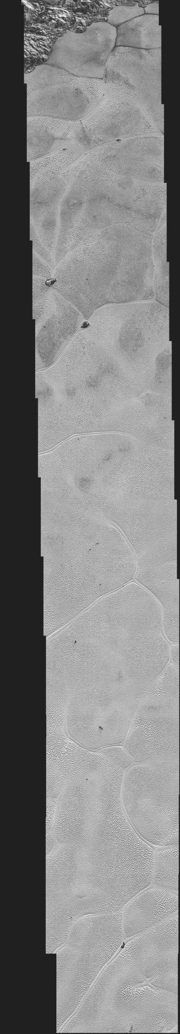
NASA’s New Horizons spacecraft continues to transmit the sharpest views of Pluto that it obtained (and recorded) during its July 14, 2015 flyby.
The newest image, returned on Dec. 24, extends New Horizons’ highest-resolution swath of Pluto to the center of the informally named Sputnik Planum, and nearly completes the set of highest-resolution images taken by New Horizons.
The pictures are part of a sequence taken near New Horizons’ closest approach to Pluto, with resolutions of about 250-280 feet (77-85 meters) per pixel – revealing features smaller than half a city block on Pluto’s surface. The images illustrate the polygonal or cellular pattern of the plains, which are thought to result from the convective churning of a deep layer solid, but mobile, nitrogen ice.
The images shown here form a strip 50 miles (80 kilometers) wide and more than 400 miles (700 kilometers) long, trending from the northwestern shoreline of Sputnik Planum and out across its icy plains. They were made with the telescopic Long Range Reconnaissance Imager (LORRI) aboard New Horizons, from a range of approximately 10,000 miles (17,000 kilometers), about 15 minutes before New Horizons’ closest approach to Pluto.
The surface of Sputnik Planum appears darker toward the shore (at top), possibly implying a change in composition or surface texture. The occasional raised, darker blocks at the cell edges are probably dirty water “icebergs” that are floating in denser solid nitrogen.
The images are six times better than the resolution of the global Pluto map New Horizons obtained, and five times better than the best images of Pluto’s cousin Triton, Neptune’s large moon, obtained by Voyager 2 in 1989.
Credits: NASA/JHUAPL/SwRI