2020 Spring Flood Outlook (updated March 26, 2020)
This updated Spring Flood and Water Resources Outlook is for the Quad Cities Hydrologic Service Area (HSA), which covers portions of eastern Iowa, northwest and west central Illinois, and extreme northeast Missouri. This includes the Mississippi River from above Dubuque, Iowa to below Gregory Landing, Missouri and its tributaries. The primary tributary river basins include the Maquoketa, Wapsipinicon, Cedar, Iowa, Skunk, and Des Moines Rivers in Iowa, the Fox River in Missouri, and the Pecatonica, Rock, Green, and La Moine Rivers in Illinois. This outlook is for the time period from early April through June.
Probabalistic Hydrologic Outlook
Use the links below to find the Graphical Probabilities and the Numerical Probabilities respectively.
|
Graphical Hydrologic Outlooks |
Statistical Hydrologic Outlook | |||||
|
|
|
||||
Flood Outlook Overview - Updated 3/26/2020
Mississippi River:
Compared to the last Spring Flood Outlook issued on March 12th, there has been little change to the probabilities of all sites reaching flood stage. However, improvement continues regarding probabilities of seeing major flood stage, especially for locations north of the Quad Cities. This drop comes as a large portion of the snowmelt from the Upper Mississippi River Basin works through the area. The crest of this primary snowmelt is happening now, and is expected across the entire reach of the NWS Quad Cities Hydrologic Service Area through the last weekend of March.
With the bulk of the basin's snowpack already melted, the primary driving force for additional rises will turn to the magnitude of rains that fall over the next few months. There is still snowpack over the uppermost portion of the basin, which contains around 2 to 6 inches of water equivalent. While this alone will not cause significant rises on the Mississippi River, heavy rains occurring in tandem could lead to additional flooding.
Tributary Rivers:
Flood probabilites remain near to slightly above normal due to high soil moisture and high river flows. Flooding on these rivers will be dependent on the magnitude of rains falling over the next several months.
Key Points:Current and Forecast River Conditions - Advanced Hydrologic Prediction Service (AHPS)
 |
 |
|
| Observed Conditions | Forecast Conditions | Long-Range Outlooks |
Flood Category definitions:
Many factors are considered when determining the overall flood risk for the season, with the combination of these influences factoring into the final determination. These factors are discussed in detail below.
Winter Precipitation
 For the winter season, December through February, precipitation has been near to below normal across Iowa, western Illinois, and northeast Missouri. On the
other hand, further north across northern Iowa, Minnesota, and Wisconsin into the headwaters of some of the local rivers, precipitation has been above normal
for the winter months. The precipitation this winter has either contributed to building the snowpack, or has kept river levels high as the precipitation either fell as
rain or was snow that has already melted, with the runoff already making it into the rivers.
 |
 |
Below you will find graphics of the precipitation accumulated this winter season (left) and how this amount of moisture compares to normal in percentage (right). These graphics are courtesy of the Midwest Regional Climate Center.
 |
 |
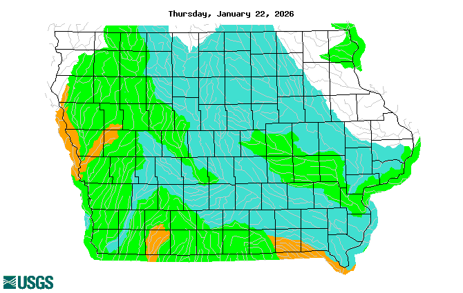
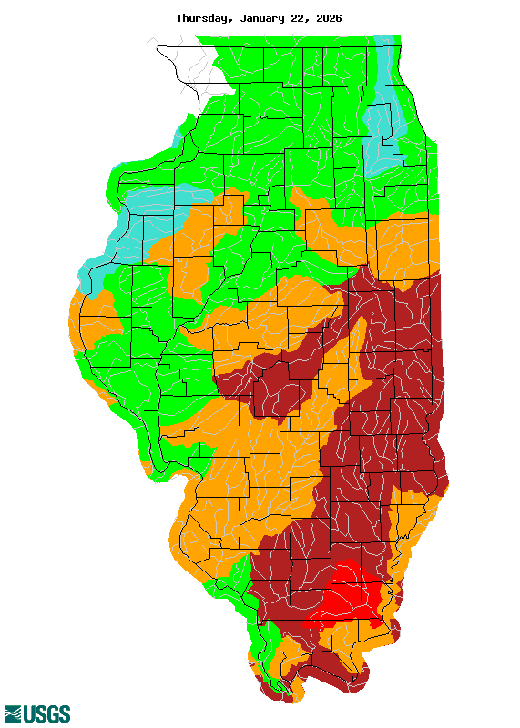
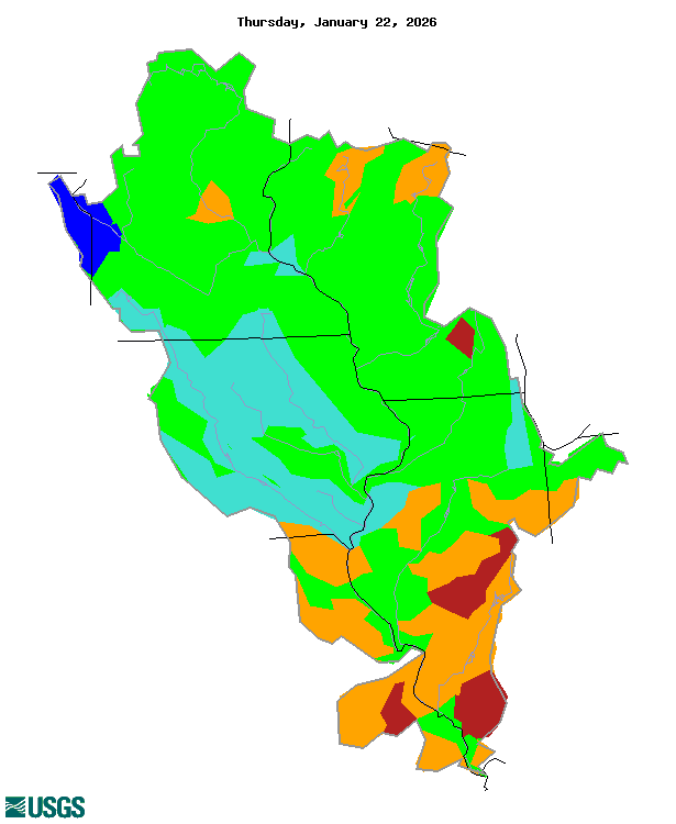
River Conditions
River levels are running above normal for this time of year. They have remained at elevated levels since fall 2019.
The significance of high streamflows to flood risk is that a river with higher water levels will have less space for additional water. As a result, flood levels can be reached with lesser runoff then it would take given normal river levels for late winter/early spring.
|
|
|
 |
 |
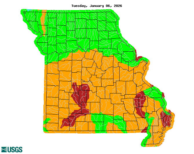 |
| Iowa | Illinois | Missouri |
| Images courtesy of the USGS |
Soil Conditions
Wet soils persisted through the winter months as moisture from last fall was locked into the soils during the cold season. Some areas have had improvement in soil moisture, but much of the region continues to observe very wet soils.
The threat for river rises from snow melt or spring rainfall runoff due to very wet soils is high for the Mississippi River as the entire watershed is experiencing very wet to saturated soils. This means very little runoff will be able to be absorbed by the soils so runoff from both snow melt and rainfall will efficiently move into the river systems. Local watersheds will also have an elevated risk for high runoff from snow melt or rainfall this spring. These watersheds are observing very wet soils across the upper parts of the watersheds, with slightly less moisture in the lower parts.
|
|
| Image courtesy of the NWS Climate Prediction Center |
Snow Cover and Liquid Water Content
Only minimal areal coverage of snowpack remains across the region as of late March. This area is confined to the far upper reaches of the Upper Mississippi River Basin.

This snow will bring increased flows into the Mississippi River, but is not expected to be enough to cause significant rises alone.
|
|
||||
|
||||
| Images courtesy of the National Operational Hydrologic Remote Sensing Center (NOHRSC) |
Frost Depth
The majority of the region now has thawed ground, so frozen ground is no longer contributing to flood potential.

The depth of frozen ground not only contributes to the flood risk by simply implying any frozen ground will cause efficient runoff from snowmelt or rainfall, but the
depth of frozen ground is also a factor to how long it might take for the ground to thaw. Shallower frozen ground could lead to an early thaw where a dry weather
pattern would work to begin drying out the ground. This lessens the length of time conditions remain at a higher threat for extreme runoff due to frozen ground or
high soil moisture.
| Frost Depths - North Central River Forecast Center | |||
Regional Frost Depths as of February 27, 2020 |
Ice Jam Flooding
Rivers are free of ice so there is no threat for ice jam flooding.
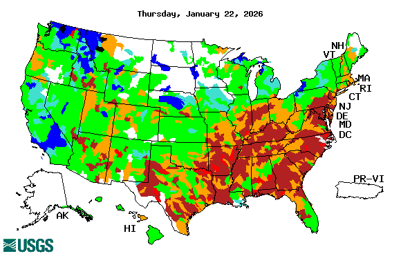
Drought
According to the U.S. Drought Monitor, there are no areas in the Midwest under drought conditions.
|
|
| Image courtesy of the US Drought Monitor |
Looking Ahead:
| 8 to 14 day Temperature Outlook | 8 to 14 day Precipitation Outlook |
 |
 |
|
March Temperature Outlook |
March Precipitation Outlook |
 |
 |
Additional Information can be found here:
River and streamflow information:
Flood safety and flood insurance information:
Precipitation, temperature, and soil moisture information:
Questions or Comments
If you have questions or comments about this spring flood and water resource outlook please contact:
Jessica Brooks
Service Hydrologist
National Weather Service
9050 Harrison St
Davenport, IA 52806
563-391-7094 ext 493
Email: jessica.brooks@noaa.gov


 Follow us on YouTube